


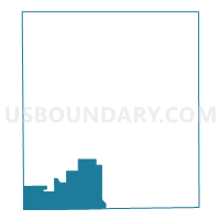
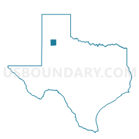
Voting District 0318, Hale County, Texas
About
Outline

Summary
| Unique Area Identifier | 673577 |
| Name | Voting District 0318 |
| County | Hale County |
| State | Texas |
| Area (square miles) | 75.20 |
| Land Area (square miles) | 75.18 |
| Water Area (square miles) | 0.03 |
| % of Land Area | 99.96 |
| % of Water Area | 0.04 |
| Latitude of the Internal Point | 33.87279860 |
| Longtitude of the Internal Point | -101.94960480 |
Maps

Graphs
Select a template below for downloading or customizing gragh for Voting District 0318, Hale County, Texas


Neighbors
Neighoring Voting District (by Name) Neighboring Voting District on the Map
- Voting District 0007, Lamb County, TX
- Voting District 0044, Hockley County, TX
- Voting District 0045, Lubbock County, TX
- Voting District 0102, Lubbock County, TX
- Voting District 0215, Hale County, TX
- Voting District 0316, Hale County, TX
- Voting District 0317, Hale County, TX
Top 10 Neighboring County Subdivision (by Population) Neighboring County Subdivision on the Map
- Lubbock CCD, Lubbock County, TX (258,538)
- Littlefield CCD, Lamb County, TX (7,301)
- Shallowater CCD, Lubbock County, TX (6,293)
- Abernathy CCD, Hale County, TX (2,682)
- Anton CCD, Hockley County, TX (1,504)
Top 10 Neighboring Place (by Population) Neighboring Place on the Map
Top 10 Neighboring Unified School District (by Population) Neighboring Unified School District on the Map
- New Deal Independent School District, TX (3,548)
- Abernathy Independent School District, TX (3,446)
- Olton Independent School District, TX (3,193)
- Anton Independent School District, TX (1,460)
- Cotton Center Independent School District, TX (388)
Top 10 Neighboring State Legislative District Lower Chamber (by Population) Neighboring State Legislative District Lower Chamber on the Map
- State House District 83, TX (173,230)
- State House District 85, TX (143,267)
- State House District 88, TX (141,962)
Top 10 Neighboring State Legislative District Upper Chamber (by Population) Neighboring State Legislative District Upper Chamber on the Map
Top 10 Neighboring 111th Congressional District (by Population) Neighboring 111th Congressional District on the Map
Top 10 Neighboring Census Tract (by Population) Neighboring Census Tract on the Map
- Census Tract 102, Lubbock County, TX (7,318)
- Census Tract 9506, Lamb County, TX (3,597)
- Census Tract 103.01, Lubbock County, TX (3,499)
- Census Tract 9509, Hale County, TX (2,682)
- Census Tract 9501, Hockley County, TX (1,504)