


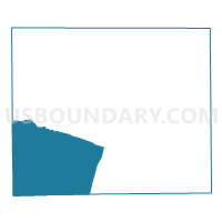
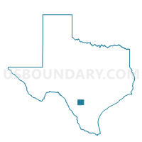
Voting District 0010, Frio County, Texas
About
Outline

Summary
| Unique Area Identifier | 673242 |
| Name | Voting District 0010 |
| County | Frio County |
| State | Texas |
| Area (square miles) | 183.29 |
| Land Area (square miles) | 183.24 |
| Water Area (square miles) | 0.05 |
| % of Land Area | 99.97 |
| % of Water Area | 0.03 |
| Latitude of the Internal Point | 28.73206780 |
| Longtitude of the Internal Point | -99.28864640 |
Maps

Graphs
Select a template below for downloading or customizing gragh for Voting District 0010, Frio County, Texas


Neighbors
Neighoring Voting District (by Name) Neighboring Voting District on the Map
- Voting District 0001, Frio County, TX
- Voting District 0001, La Salle County, TX
- Voting District 0001, Zavala County, TX
- Voting District 0002, Frio County, TX
- Voting District 0003, Dimmit County, TX
- Voting District 0004, Frio County, TX
- Voting District 0005, La Salle County, TX
- Voting District 0008, Frio County, TX
- Voting District 0009, Frio County, TX
Top 10 Neighboring County Subdivision (by Population) Neighboring County Subdivision on the Map
- Pearsall CCD, Frio County, TX (11,171)
- Crystal City CCD, Zavala County, TX (8,565)
- Cotulla CCD, La Salle County, TX (5,124)
- Dilley CCD, Frio County, TX (4,674)
- Batesville CCD, Zavala County, TX (1,232)
- Big Wells CCD, Dimmit County, TX (876)
Top 10 Neighboring Place (by Population) Neighboring Place on the Map
Top 10 Neighboring Unified School District (by Population) Neighboring Unified School District on the Map
- Pearsall Independent School District, TX (11,900)
- Carrizo Springs Consolidated Independent School District, TX (9,996)
- Crystal City Independent School District, TX (8,573)
- Dilley Independent School District, TX (4,774)
Top 10 Neighboring State Legislative District Lower Chamber (by Population) Neighboring State Legislative District Lower Chamber on the Map
Top 10 Neighboring State Legislative District Upper Chamber (by Population) Neighboring State Legislative District Upper Chamber on the Map
Top 10 Neighboring 111th Congressional District (by Population) Neighboring 111th Congressional District on the Map
Top 10 Neighboring Census Tract (by Population) Neighboring Census Tract on the Map
- Census Tract 9503, La Salle County, TX (6,886)
- Census Tract 9502, Frio County, TX (6,343)
- Census Tract 9501, Frio County, TX (6,200)
- Census Tract 9503, Frio County, TX (4,674)
- Census Tract 9504, Dimmit County, TX (2,281)
- Census Tract 9503.01, Zavala County, TX (2,254)
- Census Tract 9501, Zavala County, TX (1,232)