


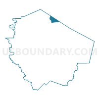
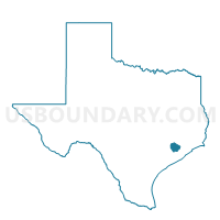
Voting District 3004, Fort Bend County, Texas
About
Outline

Summary
| Unique Area Identifier | 673077 |
| Name | Voting District 3004 |
| County | Fort Bend County |
| State | Texas |
| Area (square miles) | 5.94 |
| Land Area (square miles) | 5.56 |
| Water Area (square miles) | 0.38 |
| % of Land Area | 93.57 |
| % of Water Area | 6.43 |
| Latitude of the Internal Point | 29.72349370 |
| Longtitude of the Internal Point | -95.72303670 |
Maps

Graphs
Select a template below for downloading or customizing gragh for Voting District 3004, Fort Bend County, Texas


Neighbors
Neighoring Voting District (by Name) Neighboring Voting District on the Map
- Voting District 0362, Harris County, TX
- Voting District 0400, Harris County, TX
- Voting District 0600, Harris County, TX
- Voting District 0644, Harris County, TX
- Voting District 0772, Harris County, TX
- Voting District 3083, Fort Bend County, TX
- Voting District 3101, Fort Bend County, TX
- Voting District 3106, Fort Bend County, TX
- Voting District 3122, Fort Bend County, TX
- Voting District 3132, Fort Bend County, TX
- Voting District 3133, Fort Bend County, TX
Top 10 Neighboring County Subdivision (by Population) Neighboring County Subdivision on the Map
- Houston CCD, Harris County, TX (3,075,388)
- Sugar Land CCD, Fort Bend County, TX (248,350)
- Fulshear-Simonton CCD, Fort Bend County, TX (102,849)
Top 10 Neighboring Place (by Population) Neighboring Place on the Map
Top 10 Neighboring Unified School District (by Population) Neighboring Unified School District on the Map
- Fort Bend Independent School District, TX (348,526)
- Katy Independent School District, TX (256,979)
- Alief Independent School District, TX (256,592)
- Lamar Consolidated Independent School District, TX (122,887)
Top 10 Neighboring State Legislative District Lower Chamber (by Population) Neighboring State Legislative District Lower Chamber on the Map
- State House District 132, TX (264,426)
- State House District 28, TX (263,682)
- State House District 149, TX (169,836)
Top 10 Neighboring State Legislative District Upper Chamber (by Population) Neighboring State Legislative District Upper Chamber on the Map
Top 10 Neighboring 111th Congressional District (by Population) Neighboring 111th Congressional District on the Map
- Congressional District 10, TX (981,367)
- Congressional District 22, TX (910,877)
- Congressional District 14, TX (779,704)
- Congressional District 9, TX (733,796)
Top 10 Neighboring Census Tract (by Population) Neighboring Census Tract on the Map
- Census Tract 6729, Fort Bend County, TX (28,537)
- Census Tract 6730.03, Fort Bend County, TX (12,920)
- Census Tract 4549, Harris County, TX (10,460)
- Census Tract 6730.01, Fort Bend County, TX (8,459)
- Census Tract 6730.02, Fort Bend County, TX (7,617)
- Census Tract 4543.02, Harris County, TX (6,490)
- Census Tract 4550, Harris County, TX (2,838)
- Census Tract 4545.02, Harris County, TX (2,553)
- Census Tract 4544, Harris County, TX (282)