


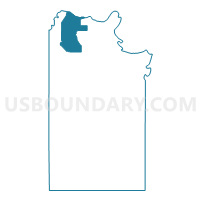
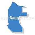
Voting District 0014, Clay County, Texas
About
Outline

Summary
| Unique Area Identifier | 671486 |
| Name | Voting District 0014 |
| County | Clay County |
| State | Texas |
| Area (square miles) | 46.27 |
| Land Area (square miles) | 46.07 |
| Water Area (square miles) | 0.20 |
| % of Land Area | 99.57 |
| % of Water Area | 0.43 |
| Latitude of the Internal Point | 34.06373970 |
| Longtitude of the Internal Point | -98.32294610 |
Maps


Graphs
Select a template below for downloading or customizing gragh for Voting District 0014, Clay County, Texas


Neighbors
Neighoring Voting District (by Name) Neighboring Voting District on the Map
- Voting District 0006, Clay County, TX
- Voting District 0011, Clay County, TX
- Voting District 0013, Clay County, TX
- Voting District 0027, Clay County, TX
- Voting District 6, Cotton County, OK
Top 10 Neighboring County Subdivision (by Population) Neighboring County Subdivision on the Map
- Byers-Petrolia CCD, Clay County, TX (2,237)
- Temple CCD, Cotton County, OK (1,252)
- Southwest Cotton CCD, Cotton County, OK (1,147)
Top 10 Neighboring Unified School District (by Population) Neighboring Unified School District on the Map
- Burkburnett Independent School District, TX (22,258)
- Petrolia Independent School District, TX (2,157)
- Temple Public Schools, OK (1,333)
- Byers Independent School District, TX (717)