


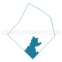
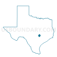
Voting District 2004, Bastrop County, Texas
About
Outline

Summary
| Unique Area Identifier | 670226 |
| Name | Voting District 2004 |
| County | Bastrop County |
| State | Texas |
| Area (square miles) | 104.27 |
| Land Area (square miles) | 104.02 |
| Water Area (square miles) | 0.25 |
| % of Land Area | 99.76 |
| % of Water Area | 0.24 |
| Latitude of the Internal Point | 29.91190550 |
| Longtitude of the Internal Point | -97.31776810 |
Maps

Graphs
Select a template below for downloading or customizing gragh for Voting District 2004, Bastrop County, Texas


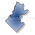

Neighbors
Neighoring Voting District (by Name) Neighboring Voting District on the Map
- Voting District 0015, Fayette County, TX
- Voting District 0205, Caldwell County, TX
- Voting District 0207, Caldwell County, TX
- Voting District 1001, Bastrop County, TX
- Voting District 2003, Bastrop County, TX
- Voting District 2016, Bastrop County, TX
- Voting District 2017, Bastrop County, TX
- Voting District 3009, Bastrop County, TX
- Voting District 3010, Bastrop County, TX
Top 10 Neighboring County Subdivision (by Population) Neighboring County Subdivision on the Map
- Cedar Creek-Red Rock CCD, Bastrop County, TX (25,834)
- Lockhart CCD, Caldwell County, TX (22,448)
- Bastrop CCD, Bastrop County, TX (22,401)
- Smithville CCD, Bastrop County, TX (9,373)
- Luling CCD, Caldwell County, TX (8,016)
- Flatonia CCD, Fayette County, TX (3,847)
Top 10 Neighboring Unified School District (by Population) Neighboring Unified School District on the Map
- Bastrop Independent School District, TX (46,645)
- Lockhart Independent School District, TX (23,728)
- Smithville Independent School District, TX (10,748)
- Flatonia Independent School District, TX (3,517)
- Waelder Independent School District, TX (2,015)
Top 10 Neighboring State Legislative District Lower Chamber (by Population) Neighboring State Legislative District Lower Chamber on the Map
Top 10 Neighboring State Legislative District Upper Chamber (by Population) Neighboring State Legislative District Upper Chamber on the Map
Top 10 Neighboring 111th Congressional District (by Population) Neighboring 111th Congressional District on the Map
Top 10 Neighboring Census Tract (by Population) Neighboring Census Tract on the Map
- Census Tract 9503, Bastrop County, TX (12,927)
- Census Tract 9505.02, Bastrop County, TX (6,409)
- Census Tract 9508.02, Bastrop County, TX (6,387)
- Census Tract 9506, Bastrop County, TX (5,184)
- Census Tract 9705, Fayette County, TX (3,847)
- Census Tract 9601.02, Caldwell County, TX (3,840)
- Census Tract 9606, Caldwell County, TX (2,356)
Top 10 Neighboring 5-Digit ZIP Code Tabulation Area (by Population) Neighboring 5-Digit ZIP Code Tabulation Area on the Map
- 78602, TX (25,160)
- 78957, TX (9,067)
- 78941, TX (2,962)
- 78662, TX (2,268)
- 78959, TX (1,837)
- 78953, TX (934)