


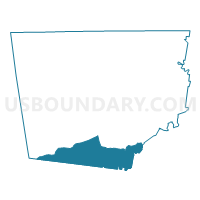
4B Voting District, Montgomery County, Tennessee
About
Outline

Summary
| Unique Area Identifier | 669277 |
| Name | 4B Voting District |
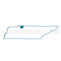
| County | Montgomery County |
| State | Tennessee |
| Area (square miles) | 45.68 |
| Land Area (square miles) | 45.68 |
| Water Area (square miles) | 0.00 |
| % of Land Area | 100.00 |
| % of Water Area | 0.00 |
| Latitude of the Internal Point | 36.34876800 |
| Longtitude of the Internal Point | -87.39152800 |
Maps

Graphs
Select a template below for downloading or customizing gragh for 4B Voting District, Montgomery County, Tennessee


Neighbors
Neighoring Voting District (by Name) Neighboring Voting District on the Map
- 03-1 Cumberland Fce Firehall Voting District, Dickson County, TN
- 03-2 Vanleer Townhall Voting District, Dickson County, TN
- 04-1 Jackson Chapel C.C. Voting District, Dickson County, TN
- 4-2 New Hope Community Center Voting District, Cheatham County, TN
- 4A Voting District, Montgomery County, TN
- 6A Voting District, Montgomery County, TN
- 6B Voting District, Montgomery County, TN
- Griffin's Chapel Church Voting District, Houston County, TN
Top 10 Neighboring County Subdivision (by Population) Neighboring County Subdivision on the Map
- District 4, Montgomery County, TN (6,941)
- District 6, Montgomery County, TN (6,645)
- District 4, Cheatham County, TN (6,604)
- District 3, Dickson County, TN (3,865)
- District 4, Dickson County, TN (3,821)
- District 7, Houston County, TN (1,227)
Top 10 Neighboring Unified School District (by Population) Neighboring Unified School District on the Map
- Montgomery County School District, TN (166,179)
- Dickson County School District, TN (49,666)
- Cheatham County School District, TN (39,105)
- Houston County School District, TN (8,426)
Top 10 Neighboring State Legislative District Lower Chamber (by Population) Neighboring State Legislative District Lower Chamber on the Map
- State House District 68, TN (85,127)
- State House District 78, TN (66,061)
- State House District 69, TN (62,378)
- State House District 74, TN (58,574)
Top 10 Neighboring State Legislative District Upper Chamber (by Population) Neighboring State Legislative District Upper Chamber on the Map
Top 10 Neighboring 111th Congressional District (by Population) Neighboring 111th Congressional District on the Map
Top 10 Neighboring Census Tract (by Population) Neighboring Census Tract on the Map
- Census Tract 1017, Montgomery County, TN (8,091)
- Census Tract 602, Dickson County, TN (6,625)
- Census Tract 601, Dickson County, TN (4,210)
- Census Tract 702.03, Cheatham County, TN (3,543)
- Census Tract 1201, Houston County, TN (3,228)
Top 10 Neighboring 5-Digit ZIP Code Tabulation Area (by Population) Neighboring 5-Digit ZIP Code Tabulation Area on the Map
- 37036, TN (5,862)
- 37061, TN (5,153)
- 37051, TN (3,677)
- 37052, TN (2,656)
- 37142, TN (1,902)
- 37050, TN (1,699)
- 37171, TN (917)