


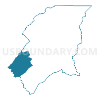
4B Butler Voting District, Johnson County, Tennessee
About
Outline

Summary
| Unique Area Identifier | 668929 |
| Name | 4B Butler Voting District |
| County | Johnson County |
| State | Tennessee |
| Area (square miles) | 26.76 |
| Land Area (square miles) | 25.00 |
| Water Area (square miles) | 1.76 |
| % of Land Area | 93.43 |
| % of Water Area | 6.57 |
| Latitude of the Internal Point | 36.37636930 |
| Longtitude of the Internal Point | -81.99914790 |
Maps

Graphs
Select a template below for downloading or customizing gragh for 4B Butler Voting District, Johnson County, Tennessee


Neighbors
Neighoring Voting District (by Name) Neighboring Voting District on the Map
- 4A Dry Run Voting District, Johnson County, TN
- 5 Doe Voting District, Johnson County, TN
- Hunter Voting District, Carter County, TN
- Little Milligan Voting District, Carter County, TN
- Midway Voting District, Carter County, TN
- Unaka Voting District, Carter County, TN
Top 10 Neighboring County Subdivision (by Population) Neighboring County Subdivision on the Map
- District 1, Carter County, TN (7,651)
- District 6, Carter County, TN (6,815)
- District 5, Johnson County, TN (3,885)
- District 4, Johnson County, TN (2,594)
Top 10 Neighboring Unified School District (by Population) Neighboring Unified School District on the Map
Top 10 Neighboring State Legislative District Lower Chamber (by Population) Neighboring State Legislative District Lower Chamber on the Map
Top 10 Neighboring State Legislative District Upper Chamber (by Population) Neighboring State Legislative District Upper Chamber on the Map
Top 10 Neighboring 111th Congressional District (by Population) Neighboring 111th Congressional District on the Map
Top 10 Neighboring Census Tract (by Population) Neighboring Census Tract on the Map
- Census Tract 713, Carter County, TN (7,317)
- Census Tract 9561, Johnson County, TN (4,161)
- Census Tract 9562, Johnson County, TN (2,446)
- Census Tract 716, Carter County, TN (1,587)