


VTD-Perry twshp, Lincoln County, South Dakota
About
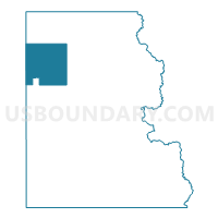
Outline

Summary
| Unique Area Identifier | 667473 |
| Name | VTD-Perry twshp |
| County | Lincoln County |
| State | South Dakota |
| Area (square miles) | 34.70 |
| Land Area (square miles) | 34.70 |
| Water Area (square miles) | 0.01 |
| % of Land Area | 99.98 |
| % of Water Area | 0.02 |
| Latitude of the Internal Point | 43.39385590 |
| Longtitude of the Internal Point | -96.85811130 |
Maps


Graphs
Select a template below for downloading or customizing gragh for VTD-Perry twshp, Lincoln County, South Dakota


Neighbors
Neighoring Voting District (by Name) Neighboring Voting District on the Map
- VTD - DelapreTwp, Lincoln County, SD
- VTD - La ValleyTwp, Lincoln County, SD
- VTD - Lennox Ward 1 (part of precinct 25), Lincoln County, SD
- VTD - Lennox Ward 2 (part of precinct 25), Lincoln County, SD
- VTD - Lennox Ward 3 (part of precinct 25), Lincoln County, SD
- VTD - LynnTwp-WorthingTown, Lincoln County, SD
- VTD-GrantTwp, Lincoln County, SD
- VTD-precinct 2, Turner County, SD
- VTD-precinct 3, Turner County, SD
Top 10 Neighboring County Subdivision (by Population) Neighboring County Subdivision on the Map
- Lennox city, Lincoln County, SD (2,111)
- Delapre township, Lincoln County, SD (1,805)
- Perry township, Lincoln County, SD (853)
- La Valley township, Lincoln County, SD (550)
- Germantown township, Turner County, SD (358)
- Grant township, Lincoln County, SD (354)
- Home township, Turner County, SD (323)
- Lynn township, Lincoln County, SD (298)
Top 10 Neighboring Place (by Population) Neighboring Place on the Map
Top 10 Neighboring Unified School District (by Population) Neighboring Unified School District on the Map
Top 10 Neighboring State Legislative District Lower Chamber (by Population) Neighboring State Legislative District Lower Chamber on the Map
- State House District 10, SD (35,025)
- State House District 12, SD (29,821)
- State House District 16, SD (23,892)
- State House District 17, SD (20,551)
Top 10 Neighboring State Legislative District Upper Chamber (by Population) Neighboring State Legislative District Upper Chamber on the Map
- State Senate District 10, SD (35,025)
- State Senate District 12, SD (29,821)
- State Senate District 16, SD (23,892)
- State Senate District 17, SD (20,551)
Top 10 Neighboring 111th Congressional District (by Population) Neighboring 111th Congressional District on the Map
Top 10 Neighboring Census Tract (by Population) Neighboring Census Tract on the Map
- Census Tract 103, Lincoln County, SD (4,493)
- Census Tract 101.01, Lincoln County, SD (4,399)
- Census Tract 9651, Turner County, SD (4,147)
- Census Tract 101.08, Lincoln County, SD (1,767)
- Census Tract 101.05, Lincoln County, SD (670)