


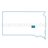
VTD-precinct 3, Jerauld County, South Dakota
About
Outline

Summary
| Unique Area Identifier | 667415 |
| Name | VTD-precinct 3 |
| County | Jerauld County |
| State | South Dakota |
| Area (square miles) | 35.06 |
| Land Area (square miles) | 34.70 |
| Water Area (square miles) | 0.35 |
| % of Land Area | 98.99 |
| % of Water Area | 1.01 |
| Latitude of the Internal Point | 44.15555180 |
| Longtitude of the Internal Point | -98.38177570 |
Maps

Graphs
Select a template below for downloading or customizing gragh for VTD-precinct 3, Jerauld County, South Dakota


Neighbors
Neighoring Voting District (by Name) Neighboring Voting District on the Map
- VTD-Huron precinct W7-2, Beadle County, SD
- VTD-precinct 12, Beadle County, SD
- VTD-precinct 2, Jerauld County, SD
- VTD-precinct 4, Jerauld County, SD
- VTD-precinct 4, Sanborn County, SD
- VTD-precinct 5, Sanborn County, SD
Top 10 Neighboring County Subdivision (by Population) Neighboring County Subdivision on the Map
- Alpena town, Jerauld County, SD (286)
- Woonsocket township, Sanborn County, SD (149)
- Grant township, Beadle County, SD (116)
- Carlyle township, Beadle County, SD (76)
- Alpena township, Jerauld County, SD (68)
- Wessington Springs township, Jerauld County, SD (66)
- Warren township, Sanborn County, SD (60)
- Franklin township, Jerauld County, SD (52)
- Dale UT, Jerauld County, SD (31)
Top 10 Neighboring Place (by Population) Neighboring Place on the Map
Top 10 Neighboring Unified School District (by Population) Neighboring Unified School District on the Map
- Huron School District 02-2, SD (15,123)
- Wessington Springs School District 36-2, SD (1,884)
- Woonsocket School District 55-4, SD (1,217)
Top 10 Neighboring State Legislative District Lower Chamber (by Population) Neighboring State Legislative District Lower Chamber on the Map
- State House District 22, SD (21,252)
- State House District 8, SD (20,647)
- State House District 6, SD (19,896)
Top 10 Neighboring State Legislative District Upper Chamber (by Population) Neighboring State Legislative District Upper Chamber on the Map
- State Senate District 22, SD (21,252)
- State Senate District 8, SD (20,647)
- State Senate District 6, SD (19,896)
Top 10 Neighboring 111th Congressional District (by Population) Neighboring 111th Congressional District on the Map
Top 10 Neighboring Census Tract (by Population) Neighboring Census Tract on the Map
- Census Tract 9621, Sanborn County, SD (2,355)
- Census Tract 9741, Jerauld County, SD (2,071)
- Census Tract 9566, Beadle County, SD (1,999)
- Census Tract 9567, Beadle County, SD (1,922)