


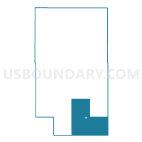
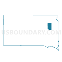
VTD-precinct 7, Clark County, South Dakota
About
Outline

Summary
| Unique Area Identifier | 667123 |
| Name | VTD-precinct 7 |
| County | Clark County |
| State | South Dakota |
| Area (square miles) | 107.09 |
| Land Area (square miles) | 105.49 |
| Water Area (square miles) | 1.60 |
| % of Land Area | 98.51 |
| % of Water Area | 1.49 |
| Latitude of the Internal Point | 44.61171760 |
| Longtitude of the Internal Point | -97.62430110 |
Maps

Graphs
Select a template below for downloading or customizing gragh for VTD-precinct 7, Clark County, South Dakota


Neighbors
Neighoring Voting District (by Name) Neighboring Voting District on the Map
- VTD - precinct 1, Kingsbury County, SD
- VTD Bryant precinct, Hamlin County, SD
- VTD-precinct 10, Clark County, SD
- VTD-precinct 24, Kingsbury County, SD
- VTD-precinct 5, Clark County, SD
- VTD-precinct 6, Clark County, SD
- VTD-precinct 8, Clark County, SD
- VTD-precinct 9, Clark County, SD
Top 10 Neighboring County Subdivision (by Population) Neighboring County Subdivision on the Map
- Willow Lake city, Clark County, SD (263)
- Pleasant township, Clark County, SD (166)
- Spirit Lake township, Kingsbury County, SD (130)
- Collins township, Clark County, SD (129)
- Garfield township, Hamlin County, SD (118)
- Dixon township, Hamlin County, SD (116)
- Le Sueur township, Kingsbury County, SD (113)
- Lake township, Clark County, SD (79)
- Rosedale township, Clark County, SD (71)
- Washington township, Clark County, SD (67)
Top 10 Neighboring Place (by Population) Neighboring Place on the Map
Top 10 Neighboring Unified School District (by Population) Neighboring Unified School District on the Map
- Hamlin School District 28-3, SD (3,314)
- Clark School District 12-2, SD (2,566)
- De Smet School District 38-2, SD (1,727)
- Iroquois School District 02-3, SD (1,227)
- Lake Preston School District 38-3, SD (1,174)
- Willow Lake School District 12-3, SD (1,060)
Top 10 Neighboring State Legislative District Lower Chamber (by Population) Neighboring State Legislative District Lower Chamber on the Map
Top 10 Neighboring State Legislative District Upper Chamber (by Population) Neighboring State Legislative District Upper Chamber on the Map
Top 10 Neighboring 111th Congressional District (by Population) Neighboring 111th Congressional District on the Map
Top 10 Neighboring Census Tract (by Population) Neighboring Census Tract on the Map
- Census Tract 9558, Clark County, SD (3,691)
- Census Tract 9552, Hamlin County, SD (3,151)
- Census Tract 9581, Kingsbury County, SD (3,117)
- Census Tract 9582, Kingsbury County, SD (2,031)