


Rembert Voting District, Sumter County, South Carolina
About
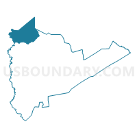
Outline

Summary
| Unique Area Identifier | 666835 |
| Name | Rembert Voting District |
| County | Sumter County |
| State | South Carolina |
| Area (square miles) | 50.72 |
| Land Area (square miles) | 50.09 |
| Water Area (square miles) | 0.63 |
| % of Land Area | 98.76 |
| % of Water Area | 1.24 |
| Latitude of the Internal Point | 34.08908550 |
| Longtitude of the Internal Point | -80.53882250 |
Maps


Graphs
Select a template below for downloading or customizing gragh for Rembert Voting District, Sumter County, South Carolina


Neighbors
Neighoring Voting District (by Name) Neighboring Voting District on the Map
- Cherlotte Thompson Voting District, Kershaw County, SC
- Doby's Mill Voting District, Kershaw County, SC
- Garners Voting District, Richland County, SC
- Hillcrest Voting District, Sumter County, SC
- Horatio Voting District, Sumter County, SC
- Pontiac Voting District, Richland County, SC
- Spring Hill Voting District, Lee County, SC
- Thomas Sumpter Voting District, Sumter County, SC
Top 10 Neighboring County Subdivision (by Population) Neighboring County Subdivision on the Map
- Elgin CCD, Kershaw County, SC (29,091)
- Shaw AFB-Horatio CCD, Sumter County, SC (21,960)
- Sumter North CCD, Sumter County, SC (5,720)
- Eastover CCD, Richland County, SC (5,433)
- Ashwood CCD, Lee County, SC (4,001)
- Rembert CCD, Sumter County, SC (3,679)
- Boykin CCD, Kershaw County, SC (2,987)
Top 10 Neighboring Place (by Population) Neighboring Place on the Map
Top 10 Neighboring Unified School District (by Population) Neighboring Unified School District on the Map
- Richland School District 1, SC (201,528)
- Richland School District 2, SC (126,150)
- Kershaw County School District, SC (61,697)
- Sumter School District 2, SC (57,252)
- Lee County School District, SC (19,220)
Top 10 Neighboring State Legislative District Lower Chamber (by Population) Neighboring State Legislative District Lower Chamber on the Map
- State House District 80, SC (39,082)
- State House District 52, SC (34,835)
- State House District 50, SC (33,358)
- State House District 70, SC (28,992)
Top 10 Neighboring State Legislative District Upper Chamber (by Population) Neighboring State Legislative District Upper Chamber on the Map
- State Senate District 22, SC (126,092)
- State Senate District 21, SC (95,133)
- State Senate District 27, SC (91,873)
- State Senate District 35, SC (87,583)
Top 10 Neighboring 111th Congressional District (by Population) Neighboring 111th Congressional District on the Map
Top 10 Neighboring Census Tract (by Population) Neighboring Census Tract on the Map
- Census Tract 4, Sumter County, SC (8,538)
- Census Tract 2.02, Sumter County, SC (5,695)
- Census Tract 120, Richland County, SC (5,433)
- Census Tract 2.01, Sumter County, SC (4,248)
- Census Tract 9204, Lee County, SC (4,001)
- Census Tract 1, Sumter County, SC (3,679)
- Census Tract 9709.02, Kershaw County, SC (3,029)
- Census Tract 9707, Kershaw County, SC (2,987)
Top 10 Neighboring 5-Digit ZIP Code Tabulation Area (by Population) Neighboring 5-Digit ZIP Code Tabulation Area on the Map
- 29020, SC (22,463)
- 29078, SC (15,293)
- 29040, SC (8,767)
- 29128, SC (5,866)
- 29044, SC (5,652)
- 29062, SC (176)