


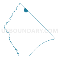
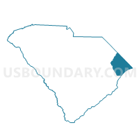
Norton Voting District, Horry County, South Carolina
About
Outline

Summary
| Unique Area Identifier | 666114 |
| Name | Norton Voting District |
| County | Horry County |
| State | South Carolina |
| Area (square miles) | 8.76 |
| Land Area (square miles) | 8.76 |
| Water Area (square miles) | 0.00 |
| % of Land Area | 100.00 |
| % of Water Area | 0.00 |
| Latitude of the Internal Point | 34.20001210 |
| Longtitude of the Internal Point | -78.98490440 |
Maps

Graphs
Select a template below for downloading or customizing gragh for Norton Voting District, Horry County, South Carolina


Neighbors
Neighoring Voting District (by Name) Neighboring Voting District on the Map
- Floyds Voting District, Horry County, SC
- Green Sea Voting District, Horry County, SC
- Mt. Olive Voting District, Horry County, SC
- Voting District P08, Columbus County, NC
- Voting District P09, Columbus County, NC
- Spring Branch Voting District, Horry County, SC
Top 10 Neighboring County Subdivision (by Population) Neighboring County Subdivision on the Map
- Loris CCD, Horry County, SC (15,878)
- Floyds Crossroads CCD, Horry County, SC (3,301)
- Cerro Gordo township, Columbus County, NC (2,152)
- Fair Bluff township, Columbus County, NC (1,788)
Top 10 Neighboring Unified School District (by Population) Neighboring Unified School District on the Map
Top 10 Neighboring State Legislative District Lower Chamber (by Population) Neighboring State Legislative District Lower Chamber on the Map
Top 10 Neighboring State Legislative District Upper Chamber (by Population) Neighboring State Legislative District Upper Chamber on the Map
Top 10 Neighboring 111th Congressional District (by Population) Neighboring 111th Congressional District on the Map
Top 10 Neighboring Census Tract (by Population) Neighboring Census Tract on the Map
- Census Tract 9306, Columbus County, NC (3,878)
- Census Tract 101, Horry County, SC (3,301)
- Census Tract 201, Horry County, SC (2,924)