


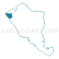
Lodge Voting District, Colleton County, South Carolina
About
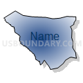
Outline

Summary
| Unique Area Identifier | 665533 |
| Name | Lodge Voting District |
| County | Colleton County |
| State | South Carolina |
| Area (square miles) | 24.51 |
| Land Area (square miles) | 24.49 |
| Water Area (square miles) | 0.02 |
| % of Land Area | 99.93 |
| % of Water Area | 0.07 |
| Latitude of the Internal Point | 33.00284450 |
| Longtitude of the Internal Point | -81.00478310 |
Maps


Graphs
Select a template below for downloading or customizing gragh for Lodge Voting District, Colleton County, South Carolina


Neighbors
Neighoring Voting District (by Name) Neighboring Voting District on the Map
- Crocket-Miley Voting District, Hampton County, SC
- Erhardt Voting District, Bamberg County, SC
- Lodge Voting District, Colleton County, SC
- Rice Patch Voting District, Colleton County, SC
- Rivers Mill Voting District, Hampton County, SC
- Sycamore Voting District, Allendale County, SC
Top 10 Neighboring County Subdivision (by Population) Neighboring County Subdivision on the Map
- Hampton-Varnville CCD, Hampton County, SC (8,708)
- Lodge CCD, Colleton County, SC (1,711)
- Ehrhardt CCD, Bamberg County, SC (1,554)
- Brunson CCD, Hampton County, SC (1,151)
- Sycamore CCD, Allendale County, SC (1,068)
Top 10 Neighboring Unified School District (by Population) Neighboring Unified School District on the Map
- Colleton County School District, SC (38,892)
- Hampton School District 1, SC (13,703)
- Allendale County School District, SC (10,419)
- Bamberg School District 1, SC (8,810)
Top 10 Neighboring State Legislative District Lower Chamber (by Population) Neighboring State Legislative District Lower Chamber on the Map
- State House District 120, SC (33,404)
- State House District 90, SC (32,339)
- State House District 91, SC (30,470)
Top 10 Neighboring State Legislative District Upper Chamber (by Population) Neighboring State Legislative District Upper Chamber on the Map
Top 10 Neighboring 111th Congressional District (by Population) Neighboring 111th Congressional District on the Map
Top 10 Neighboring Census Tract (by Population) Neighboring Census Tract on the Map
- Census Tract 9202, Hampton County, SC (7,228)
- Census Tract 9201, Hampton County, SC (2,631)
- Census Tract 9702, Colleton County, SC (1,711)
- Census Tract 9604, Bamberg County, SC (1,554)
- Census Tract 9703, Allendale County, SC (1,068)
Top 10 Neighboring 5-Digit ZIP Code Tabulation Area (by Population) Neighboring 5-Digit ZIP Code Tabulation Area on the Map
- 29827, SC (4,624)
- 29924, SC (4,331)
- 29911, SC (1,725)
- 29081, SC (1,352)
- 29929, SC (1,135)
- 29082, SC (572)