


FARMINGTON TWP Voting District, Tioga County, Pennsylvania
About
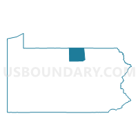
Outline

Summary
| Unique Area Identifier | 664003 |
| Name | FARMINGTON TWP Voting District |
| County | Tioga County |
| State | Pennsylvania |
| Area (square miles) | 31.73 |
| Land Area (square miles) | 31.73 |
| Water Area (square miles) | 0.00 |
| % of Land Area | 100.00 |
| % of Water Area | 0.00 |
| Latitude of the Internal Point | 41.93190830 |
| Longtitude of the Internal Point | -77.27358490 |
Maps


Graphs
Select a template below for downloading or customizing gragh for FARMINGTON TWP Voting District, Tioga County, Pennsylvania


Neighbors
Neighoring Voting District (by Name) Neighboring Voting District on the Map
- CHATHAM TWP Voting District, Tioga County, PA
- DEERFIELD TWP Voting District, Tioga County, PA
- LAWRENCE TWP Voting District, Tioga County, PA
- MIDDLEBURY TWP Voting District, Tioga County, PA
- NELSON TWP Voting District, Tioga County, PA
- OSCEOLA TWP Voting District, Tioga County, PA
- TIOGA TWP Voting District, Tioga County, PA
Top 10 Neighboring County Subdivision (by Population) Neighboring County Subdivision on the Map
- Lawrence township, Tioga County, PA (1,718)
- Middlebury township, Tioga County, PA (1,285)
- Tioga township, Tioga County, PA (991)
- Deerfield township, Tioga County, PA (662)
- Osceola township, Tioga County, PA (659)
- Farmington township, Tioga County, PA (637)
- Chatham township, Tioga County, PA (588)
- Nelson township, Tioga County, PA (571)
Top 10 Neighboring Unified School District (by Population) Neighboring Unified School District on the Map
Top 10 Neighboring State Legislative District Lower Chamber (by Population) Neighboring State Legislative District Lower Chamber on the Map
Top 10 Neighboring State Legislative District Upper Chamber (by Population) Neighboring State Legislative District Upper Chamber on the Map
Top 10 Neighboring 111th Congressional District (by Population) Neighboring 111th Congressional District on the Map
Top 10 Neighboring Census Tract (by Population) Neighboring Census Tract on the Map
- Census Tract 9501, Tioga County, PA (4,186)
- Census Tract 9504, Tioga County, PA (4,111)
- Census Tract 9503, Tioga County, PA (3,823)
- Census Tract 9502, Tioga County, PA (3,688)
Top 10 Neighboring 5-Digit ZIP Code Tabulation Area (by Population) Neighboring 5-Digit ZIP Code Tabulation Area on the Map
- 16946, PA (2,484)
- 16929, PA (2,320)
- 16920, PA (2,006)
- 16928, PA (1,387)
- 16935, PA (1,256)
- 16942, PA (847)