


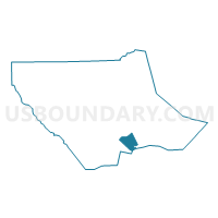
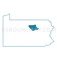
CLINTON TWP PCT 01, Lycoming County, Pennsylvania
About
Outline

Summary
| Unique Area Identifier | 661011 |
| Name | CLINTON TWP PCT 01 |
| County | Lycoming County |
| State | Pennsylvania |
| Area (square miles) | 15.21 |
| Land Area (square miles) | 15.05 |
| Water Area (square miles) | 0.16 |
| % of Land Area | 98.95 |
| % of Water Area | 1.05 |
| Latitude of the Internal Point | 41.20331500 |
| Longtitude of the Internal Point | -76.89694090 |
Maps

Graphs
Select a template below for downloading or customizing gragh for CLINTON TWP PCT 01, Lycoming County, Pennsylvania


Neighbors
Neighoring Voting District (by Name) Neighboring Voting District on the Map
- ARMSTRONG TWP Voting District, Lycoming County, PA
- BRADY TWP Voting District, Lycoming County, PA
- CLINTON TWP PCT 02, Lycoming County, PA
- DELAWARE TWP DIST WEST, Northumberland County, PA
- MONTGOMERY Voting District, Lycoming County, PA
- MUNCY CREEK TWP Voting District, Lycoming County, PA
Top 10 Neighboring County Subdivision (by Population) Neighboring County Subdivision on the Map
- Delaware township, Northumberland County, PA (4,489)
- Clinton township, Lycoming County, PA (3,708)
- Muncy Creek township, Lycoming County, PA (3,474)
- Montgomery borough, Lycoming County, PA (1,579)
- Armstrong township, Lycoming County, PA (681)
- Brady township, Lycoming County, PA (521)
Top 10 Neighboring Place (by Population) Neighboring Place on the Map
Top 10 Neighboring Unified School District (by Population) Neighboring Unified School District on the Map
- Warrior Run School District, PA (17,290)
- South Williamsport Area School District, PA (9,265)
- Montgomery Area School District, PA (7,427)
- Muncy School District, PA (7,040)
Top 10 Neighboring State Legislative District Lower Chamber (by Population) Neighboring State Legislative District Lower Chamber on the Map
- State House District 108, PA (62,303)
- State House District 83, PA (58,867)
- State House District 84, PA (57,244)
Top 10 Neighboring State Legislative District Upper Chamber (by Population) Neighboring State Legislative District Upper Chamber on the Map
Top 10 Neighboring 111th Congressional District (by Population) Neighboring 111th Congressional District on the Map
Top 10 Neighboring Census Tract (by Population) Neighboring Census Tract on the Map
- Census Tract 117, Lycoming County, PA (7,427)
- Census Tract 802, Northumberland County, PA (7,119)
- Census Tract 108, Lycoming County, PA (7,040)
- Census Tract 114, Lycoming County, PA (1,681)