


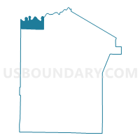
BARNETT TWP Voting District, Jefferson County, Pennsylvania
About
Outline

Summary
| Unique Area Identifier | 660006 |
| Name | BARNETT TWP Voting District |
| County | Jefferson County |
| State | Pennsylvania |
| Area (square miles) | 15.14 |
| Land Area (square miles) | 14.58 |
| Water Area (square miles) | 0.56 |
| % of Land Area | 96.31 |
| % of Water Area | 3.69 |
| Latitude of the Internal Point | 41.31024220 |
| Longtitude of the Internal Point | -79.15270770 |
Maps

Graphs
Select a template below for downloading or customizing gragh for BARNETT TWP Voting District, Jefferson County, Pennsylvania


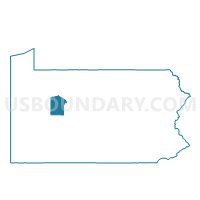
Neighbors
Neighoring Voting District (by Name) Neighboring Voting District on the Map
- BARNETT TWP Voting District, Forest County, PA
- ELDRED TWP Voting District, Jefferson County, PA
- FARMINGTON TWP VTD SOUTH, Clarion County, PA
- HEATH TWP Voting District, Jefferson County, PA
- MILLCREEK TWP Voting District, Clarion County, PA
- MILLSTONE TWP Voting District, Elk County, PA
Top 10 Neighboring County Subdivision (by Population) Neighboring County Subdivision on the Map
- Farmington township, Clarion County, PA (1,934)
- Eldred township, Jefferson County, PA (1,226)
- Millcreek township, Clarion County, PA (396)
- Barnett township, Forest County, PA (361)
- Barnett township, Jefferson County, PA (254)
- Heath township, Jefferson County, PA (124)
- Millstone township, Elk County, PA (82)
Top 10 Neighboring Unified School District (by Population) Neighboring Unified School District on the Map
- Brookville Area School District, PA (12,075)
- Forest Area School District, PA (8,287)
- Clarion-Limestone Area School District, PA (8,132)
- North Clarion County School District, PA (4,857)
Top 10 Neighboring State Legislative District Lower Chamber (by Population) Neighboring State Legislative District Lower Chamber on the Map
- State House District 65, PA (59,457)
- State House District 66, PA (58,212)
- State House District 63, PA (56,952)
- State House District 75, PA (54,981)
Top 10 Neighboring State Legislative District Upper Chamber (by Population) Neighboring State Legislative District Upper Chamber on the Map
Top 10 Neighboring 111th Congressional District (by Population) Neighboring 111th Congressional District on the Map
Top 10 Neighboring Census Tract (by Population) Neighboring Census Tract on the Map
- Census Tract 9503, Jefferson County, PA (5,565)
- Census Tract 1601.02, Clarion County, PA (5,062)
- Census Tract 5301, Forest County, PA (4,395)
- Census Tract 9502, Elk County, PA (3,330)
- Census Tract 9502, Jefferson County, PA (3,190)
- Census Tract 1601.01, Clarion County, PA (1,934)