


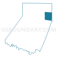
MONTGOMERY TWP Voting District, Indiana County, Pennsylvania
About
Outline

Summary
| Unique Area Identifier | 659994 |
| Name | MONTGOMERY TWP Voting District |
| County | Indiana County |
| State | Pennsylvania |
| Area (square miles) | 28.72 |
| Land Area (square miles) | 28.66 |
| Water Area (square miles) | 0.06 |
| % of Land Area | 99.78 |
| % of Water Area | 0.22 |
| Latitude of the Internal Point | 40.76613240 |
| Longtitude of the Internal Point | -78.85602160 |
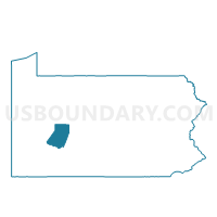
Maps

Graphs
Select a template below for downloading or customizing gragh for MONTGOMERY TWP Voting District, Indiana County, Pennsylvania


Neighbors
Neighoring Voting District (by Name) Neighboring Voting District on the Map
- BANKS TWP VTD 01, Indiana County, PA
- BURNSIDE Voting District, Clearfield County, PA
- BURNSIDE TWP Voting District, Clearfield County, PA
- CANOE TWP Voting District, Indiana County, PA
- CHERRY TREE Voting District, Indiana County, PA
- GLEN CAMPBELL Voting District, Indiana County, PA
- GRANT TWP Voting District, Indiana County, PA
- GREEN TWP VTD 01, Indiana County, PA
Top 10 Neighboring County Subdivision (by Population) Neighboring County Subdivision on the Map
- Green township, Indiana County, PA (3,839)
- Montgomery township, Indiana County, PA (1,568)
- Canoe township, Indiana County, PA (1,505)
- Burnside township, Clearfield County, PA (1,076)
- Banks township, Indiana County, PA (1,018)
- Grant township, Indiana County, PA (741)
- Cherry Tree borough, Indiana County, PA (364)
- Glen Campbell borough, Indiana County, PA (245)
- Burnside borough, Clearfield County, PA (234)
Top 10 Neighboring Place (by Population) Neighboring Place on the Map
Top 10 Neighboring Unified School District (by Population) Neighboring Unified School District on the Map
- Punxsutawney Area School District, PA (21,024)
- Marion Center Area School District, PA (10,491)
- Purchase Line School District, PA (7,165)
- Harmony Area School District, PA (2,345)
Top 10 Neighboring State Legislative District Lower Chamber (by Population) Neighboring State Legislative District Lower Chamber on the Map
- State House District 74, PA (58,607)
- State House District 66, PA (58,212)
- State House District 60, PA (58,162)
Top 10 Neighboring State Legislative District Upper Chamber (by Population) Neighboring State Legislative District Upper Chamber on the Map
Top 10 Neighboring 111th Congressional District (by Population) Neighboring 111th Congressional District on the Map
Top 10 Neighboring Census Tract (by Population) Neighboring Census Tract on the Map
- Census Tract 9601, Indiana County, PA (4,196)
- Census Tract 9604, Indiana County, PA (3,839)
- Census Tract 9603, Indiana County, PA (2,673)
- Census Tract 3319, Clearfield County, PA (2,366)
Top 10 Neighboring 5-Digit ZIP Code Tabulation Area (by Population) Neighboring 5-Digit ZIP Code Tabulation Area on the Map
- 15759, PA (3,004)
- 15724, PA (2,412)
- 15729, PA (1,537)
- 15771, PA (991)
- 15742, PA (950)
- 15721, PA (234)
- 15712, PA (151)
- 15746, PA (135)
- 15741, PA (83)