


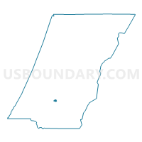
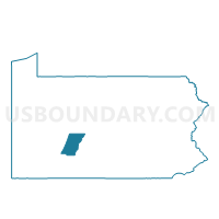
SOUTH FORK WD 02, Cambria County, Pennsylvania
About
Outline

Summary
| Unique Area Identifier | 658050 |
| Name | SOUTH FORK WD 02 |
| County | Cambria County |
| State | Pennsylvania |
| Area (square miles) | 0.29 |
| Land Area (square miles) | 0.27 |
| Water Area (square miles) | 0.01 |
| % of Land Area | 95.60 |
| % of Water Area | 4.40 |
| Latitude of the Internal Point | 40.36147370 |
| Longtitude of the Internal Point | -78.79037300 |
Maps

Graphs
Select a template below for downloading or customizing gragh for SOUTH FORK WD 02, Cambria County, Pennsylvania


Neighbors
Neighoring Voting District (by Name) Neighboring Voting District on the Map
- ADAMS TWP VTD GRAMLINGTON, Cambria County, PA
- CROYLE TWP VTD 02, Cambria County, PA
- SOUTH FORK WD 01, Cambria County, PA
Top 10 Neighboring County Subdivision (by Population) Neighboring County Subdivision on the Map
- Adams township, Cambria County, PA (5,972)
- Croyle township, Cambria County, PA (2,339)
- South Fork borough, Cambria County, PA (928)