


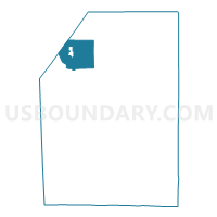
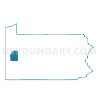
SLIPPERY ROCK TWP Voting District, Butler County, Pennsylvania
About
Outline

Summary
| Unique Area Identifier | 657961 |
| Name | SLIPPERY ROCK TWP Voting District |
| County | Butler County |
| State | Pennsylvania |
| Area (square miles) | 25.69 |
| Land Area (square miles) | 25.68 |
| Water Area (square miles) | 0.02 |
| % of Land Area | 99.94 |
| % of Water Area | 0.06 |
| Latitude of the Internal Point | 41.06482980 |
| Longtitude of the Internal Point | -80.03248900 |
Maps

Graphs
Select a template below for downloading or customizing gragh for SLIPPERY ROCK TWP Voting District, Butler County, Pennsylvania


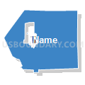


Neighbors
Neighoring Voting District (by Name) Neighboring Voting District on the Map
- BRADY TWP Voting District, Butler County, PA
- CHERRY TWP Voting District, Butler County, PA
- LIBERTY TWP Voting District, Mercer County, PA
- MARION TWP Voting District, Butler County, PA
- MERCER TWP Voting District, Butler County, PA
- PLAIN GROVE TWP Voting District, Lawrence County, PA
- SLIPPERY ROCK Voting District, Butler County, PA
- WEST LIBERTY Voting District, Butler County, PA
- WORTH TWP Voting District, Butler County, PA
Top 10 Neighboring County Subdivision (by Population) Neighboring County Subdivision on the Map
- Slippery Rock township, Butler County, PA (5,614)
- Slippery Rock borough, Butler County, PA (3,625)
- Worth township, Butler County, PA (1,416)
- Liberty township, Mercer County, PA (1,414)
- Brady township, Butler County, PA (1,310)
- Marion township, Butler County, PA (1,239)
- Cherry township, Butler County, PA (1,106)
- Mercer township, Butler County, PA (1,100)
- Plain Grove township, Lawrence County, PA (813)
- West Liberty borough, Butler County, PA (343)
Top 10 Neighboring Place (by Population) Neighboring Place on the Map
- Slippery Rock borough, PA (3,625)
- Slippery Rock University CDP, PA (1,898)
- West Liberty borough, PA (343)
Top 10 Neighboring Unified School District (by Population) Neighboring Unified School District on the Map
- Slippery Rock Area School District, PA (20,583)
- Grove City Area School District, PA (17,699)
- Wilmington Area School District, PA (11,828)
- Moniteau School District, PA (9,295)
Top 10 Neighboring State Legislative District Lower Chamber (by Population) Neighboring State Legislative District Lower Chamber on the Map
Top 10 Neighboring State Legislative District Upper Chamber (by Population) Neighboring State Legislative District Upper Chamber on the Map
Top 10 Neighboring 111th Congressional District (by Population) Neighboring 111th Congressional District on the Map
Top 10 Neighboring Census Tract (by Population) Neighboring Census Tract on the Map
- Census Tract 9102, Butler County, PA (4,895)
- Census Tract 331, Mercer County, PA (4,810)
- Census Tract 9103.01, Butler County, PA (4,503)
- Census Tract 9103.02, Butler County, PA (4,279)
- Census Tract 101, Lawrence County, PA (4,127)
- Census Tract 9104, Butler County, PA (3,625)
- Census Tract 9105, Butler County, PA (1,898)
Top 10 Neighboring 5-Digit ZIP Code Tabulation Area (by Population) Neighboring 5-Digit ZIP Code Tabulation Area on the Map
- 16127, PA (16,145)
- 16057, PA (13,909)
- 16038, PA (3,517)
- 16156, PA (3,319)
- 16020, PA (1,150)
- 16035, PA (122)