


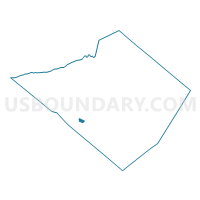
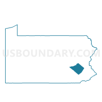
WERNERSVILLE DIST 01, Berks County, Pennsylvania
About
Outline

Summary
| Unique Area Identifier | 657367 |
| Name | WERNERSVILLE DIST 01 |
| County | Berks County |
| State | Pennsylvania |
| Area (square miles) | 0.76 |
| Land Area (square miles) | 0.76 |
| Water Area (square miles) | 0.00 |
| % of Land Area | 99.84 |
| % of Water Area | 0.16 |
| Latitude of the Internal Point | 40.33044870 |
| Longtitude of the Internal Point | -76.08265960 |
Maps

Graphs
Select a template below for downloading or customizing gragh for WERNERSVILLE DIST 01, Berks County, Pennsylvania


Neighbors
Neighoring Voting District (by Name) Neighboring Voting District on the Map
- LOWER HEIDELBERG TWP DIST 01, Berks County, PA
- SOUTH HEIDELBERG TWP PCT 02, Berks County, PA
- SOUTH HEIDELBERG TWP PCT 03, Berks County, PA
Top 10 Neighboring County Subdivision (by Population) Neighboring County Subdivision on the Map
- South Heidelberg township, Berks County, PA (7,271)
- Lower Heidelberg township, Berks County, PA (5,513)
- Wernersville borough, Berks County, PA (2,494)