


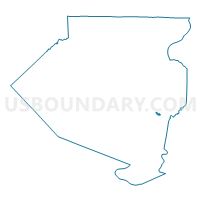
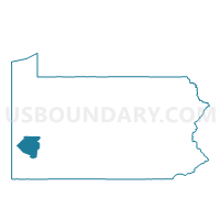
WILMERDING DIST 01, Allegheny County, Pennsylvania
About
Outline

Summary
| Unique Area Identifier | 656609 |
| Name | WILMERDING DIST 01 |
| County | Allegheny County |
| State | Pennsylvania |
| Area (square miles) | 0.21 |
| Land Area (square miles) | 0.21 |
| Water Area (square miles) | 0.00 |
| % of Land Area | 100.00 |
| % of Water Area | 0.00 |
| Latitude of the Internal Point | 40.39704500 |
| Longtitude of the Internal Point | -79.81028210 |
Maps

Graphs
Select a template below for downloading or customizing gragh for WILMERDING DIST 01, Allegheny County, Pennsylvania


Neighbors
Neighoring Voting District (by Name) Neighboring Voting District on the Map
- MONROEVILLE WD 01 DIST 01, Allegheny County, PA
- NORTH VERSAILLES TWP WD 03 DIST 02, Allegheny County, PA
- NORTH VERSAILLES TWP WD 05 DIST 01, Allegheny County, PA
- TURTLE CREEK WD 02 DIST 01, Allegheny County, PA
- WILMERDING DIST 02, Allegheny County, PA
Top 10 Neighboring County Subdivision (by Population) Neighboring County Subdivision on the Map
- Monroeville municipality, Allegheny County, PA (28,386)
- North Versailles township, Allegheny County, PA (10,229)
- Turtle Creek borough, Allegheny County, PA (5,349)
- Wilmerding borough, Allegheny County, PA (2,190)
Top 10 Neighboring Place (by Population) Neighboring Place on the Map
- Monroeville municipality, PA (28,386)
- Turtle Creek borough, PA (5,349)
- Wilmerding borough, PA (2,190)
Top 10 Neighboring Unified School District (by Population) Neighboring Unified School District on the Map
- Woodland Hills School District, PA (46,882)
- Gateway School District, PA (31,680)
- East Allegheny School District, PA (15,125)
Top 10 Neighboring State Legislative District Lower Chamber (by Population) Neighboring State Legislative District Lower Chamber on the Map
- State House District 25, PA (59,461)
- State House District 34, PA (55,844)
- State House District 35, PA (53,932)
Top 10 Neighboring State Legislative District Upper Chamber (by Population) Neighboring State Legislative District Upper Chamber on the Map
Top 10 Neighboring 111th Congressional District (by Population) Neighboring 111th Congressional District on the Map
Top 10 Neighboring Census Tract (by Population) Neighboring Census Tract on the Map
- Census Tract 5644, Allegheny County, PA (5,620)
- Census Tract 5094, Allegheny County, PA (5,349)
- Census Tract 5041, Allegheny County, PA (5,243)
- Census Tract 5213.02, Allegheny County, PA (4,378)
- Census Tract 5212, Allegheny County, PA (4,090)
- Census Tract 5080, Allegheny County, PA (2,190)