


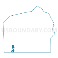
CARROLL VALLEY Voting District, Adams County, Pennsylvania
About
Outline

Summary
| Unique Area Identifier | 655644 |
| Name | CARROLL VALLEY Voting District |
| County | Adams County |
| State | Pennsylvania |
| Area (square miles) | 2.90 |
| Land Area (square miles) | 2.84 |
| Water Area (square miles) | 0.06 |
| % of Land Area | 97.94 |
| % of Water Area | 2.06 |
| Latitude of the Internal Point | 39.73942700 |
| Longtitude of the Internal Point | -77.36897090 |
Maps

Graphs
Select a template below for downloading or customizing gragh for CARROLL VALLEY Voting District, Adams County, Pennsylvania


Neighbors
Neighoring Voting District (by Name) Neighboring Voting District on the Map
- Carroll Valley Borough Voting District, Adams County, PA
- Frederick Precinct 05-001, Frederick County, MD
- HAMILTONBAN TWP Voting District, Adams County, PA
- LIBERTY TWP Voting District, Adams County, PA
Top 10 Neighboring County Subdivision (by Population) Neighboring County Subdivision on the Map
- District 5, Emmitsburg, Frederick County, MD (6,674)
- Carroll Valley borough, Adams County, PA (3,876)
- Hamiltonban township, Adams County, PA (2,372)
- Liberty township, Adams County, PA (1,237)
Top 10 Neighboring Place (by Population) Neighboring Place on the Map
Top 10 Neighboring Unified School District (by Population) Neighboring Unified School District on the Map
Top 10 Neighboring State Legislative District Lower Chamber (by Population) Neighboring State Legislative District Lower Chamber on the Map
Top 10 Neighboring State Legislative District Upper Chamber (by Population) Neighboring State Legislative District Upper Chamber on the Map
Top 10 Neighboring 111th Congressional District (by Population) Neighboring 111th Congressional District on the Map
Top 10 Neighboring Census Tract (by Population) Neighboring Census Tract on the Map
- Census Tract 316, Adams County, PA (6,887)
- Census Tract 7668, Frederick County, MD (5,131)
- Census Tract 7529, Frederick County, MD (3,066)
- Census Tract 317, Adams County, PA (2,879)