


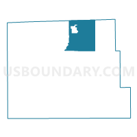
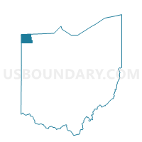
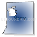
PRECINCT MADISON, Williams County, Ohio
About
Outline

Summary
| Unique Area Identifier | 653303 |
| Name | PRECINCT MADISON |
| County | Williams County |
| State | Ohio |
| Area (square miles) | 28.07 |
| Land Area (square miles) | 27.90 |
| Water Area (square miles) | 0.17 |
| % of Land Area | 99.40 |
| % of Water Area | 0.60 |
| Latitude of the Internal Point | 41.65814660 |
| Longtitude of the Internal Point | -84.52391570 |
Maps

Graphs
Select a template below for downloading or customizing gragh for PRECINCT MADISON, Williams County, Ohio


Neighbors
Neighoring Voting District (by Name) Neighboring Voting District on the Map
- Voting District 0590202000001, Hillsdale County, MI
- Voting District 0598878000001, Hillsdale County, MI
- PRECINCT BRIDGEWATER EAST, Williams County, OH
- PRECINCT JEFFERSON EAST, Williams County, OH
- PRECINCT JEFFERSON WEST, Williams County, OH
- PRECINCT MILLCREEK, Williams County, OH
- PRECINCT PIONEER NORTH, Williams County, OH
- PRECINCT PIONEER SOUTH, Williams County, OH
- PRECINCT SUPERIOR NORTH, Williams County, OH
Top 10 Neighboring County Subdivision (by Population) Neighboring County Subdivision on the Map
- Jefferson township, Williams County, OH (1,920)
- Wright township, Hillsdale County, MI (1,655)
- Bridgewater township, Williams County, OH (1,474)
- Superior township, Williams County, OH (1,393)
- Pioneer village, Williams County, OH (1,380)
- Amboy township, Hillsdale County, MI (1,173)
- Madison township, Williams County, OH (987)
- Mill Creek township, Williams County, OH (802)
Top 10 Neighboring Place (by Population) Neighboring Place on the Map
Top 10 Neighboring Unified School District (by Population) Neighboring Unified School District on the Map
Top 10 Neighboring State Legislative District Lower Chamber (by Population) Neighboring State Legislative District Lower Chamber on the Map
Top 10 Neighboring State Legislative District Upper Chamber (by Population) Neighboring State Legislative District Upper Chamber on the Map
Top 10 Neighboring 111th Congressional District (by Population) Neighboring 111th Congressional District on the Map
Top 10 Neighboring Census Tract (by Population) Neighboring Census Tract on the Map
Top 10 Neighboring 5-Digit ZIP Code Tabulation Area (by Population) Neighboring 5-Digit ZIP Code Tabulation Area on the Map
- 43543, OH (7,771)
- 43570, OH (3,106)
- 49232, MI (2,801)
- 43554, OH (2,408)
- 49288, MI (1,384)
- 43501, OH (788)
- 43531, OH (216)