


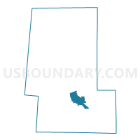
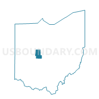
Voting District MARYSVILLE 12, Union County, Ohio
About
Outline

Summary
| Unique Area Identifier | 652887 |
| Name | Voting District MARYSVILLE 12 |
| County | Union County |
| State | Ohio |
| Area (square miles) | 6.13 |
| Land Area (square miles) | 6.07 |
| Water Area (square miles) | 0.06 |
| % of Land Area | 99.02 |
| % of Water Area | 0.98 |
| Latitude of the Internal Point | 40.21425470 |
| Longtitude of the Internal Point | -83.32713970 |
Maps

Graphs
Select a template below for downloading or customizing gragh for Voting District MARYSVILLE 12, Union County, Ohio


Neighbors
Neighoring Voting District (by Name) Neighboring Voting District on the Map
- Voting District DARBY 2, Union County, OH
- Voting District DOVER 2, Union County, OH
- Voting District JEROME 1, Union County, OH
- Voting District JEROME 5, Union County, OH
- Voting District MARYSVILLE 1, Union County, OH
- Voting District MARYSVILLE 2, Union County, OH
- Voting District MARYSVILLE 3, Union County, OH
- Voting District MILLCREEK, Union County, OH
- Voting District PARIS 2, Union County, OH
Top 10 Neighboring County Subdivision (by Population) Neighboring County Subdivision on the Map
- Paris township, Union County, OH (23,645)
- Jerome township, Union County, OH (7,541)
- Dover township, Union County, OH (2,158)
- Darby township, Union County, OH (2,060)
- Millcreek township, Union County, OH (1,305)
Top 10 Neighboring Place (by Population) Neighboring Place on the Map
Top 10 Neighboring Unified School District (by Population) Neighboring Unified School District on the Map
- Marysville Exempted Village School District, OH (30,859)
- Fairbanks Local School District, OH (6,583)
Top 10 Neighboring State Legislative District Lower Chamber (by Population) Neighboring State Legislative District Lower Chamber on the Map
Top 10 Neighboring State Legislative District Upper Chamber (by Population) Neighboring State Legislative District Upper Chamber on the Map
Top 10 Neighboring 111th Congressional District (by Population) Neighboring 111th Congressional District on the Map
Top 10 Neighboring Census Tract (by Population) Neighboring Census Tract on the Map
- Census Tract 507, Union County, OH (7,389)
- Census Tract 503.03, Union County, OH (6,648)
- Census Tract 505, Union County, OH (5,278)
- Census Tract 506.02, Union County, OH (3,945)