


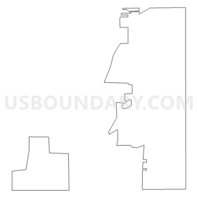
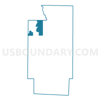
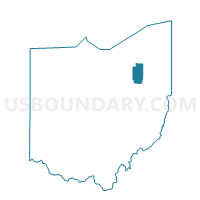
PRECINCT RICHFIELD TWP Y, Summit County, Ohio
About
Outline
Summary
| Unique Area Identifier | 652082 |
| Name | PRECINCT RICHFIELD TWP Y |
| County | Summit County |
| State | Ohio |
| Area (square miles) | 10.67 |
| Land Area (square miles) | 10.65 |
| Water Area (square miles) | 0.01 |
| % of Land Area | 99.87 |
| % of Water Area | 0.13 |
| Latitude of the Internal Point | 41.23515870 |
| Longtitude of the Internal Point | -81.61715520 |
Maps

Graphs
Select a template below for downloading or customizing gragh for PRECINCT RICHFIELD TWP Y, Summit County, Ohio


Neighbors
Neighoring Voting District (by Name) Neighboring Voting District on the Map
- Voting District BRECKSVILLE-00- L, Cuyahoga County, OH
- GRANGER TWP D Voting District, Medina County, OH
- HINCKLEY TWP A Voting District, Medina County, OH
- HINCKLEY TWP E Voting District, Medina County, OH
- PRECINCT BATH TWP E, Summit County, OH
- PRECINCT BATH TWP F, Summit County, OH
- PRECINCT BOSTON TWP, Summit County, OH
- PRECINCT RICHFIELD TWP Z, Summit County, OH
- PRECINCT RICHFIELD VILL B, Summit County, OH
- PRECINCT RICHFIELD VILL C, Summit County, OH
- PRECINCT RICHFIELD VILL D, Summit County, OH
Top 10 Neighboring County Subdivision (by Population) Neighboring County Subdivision on the Map
- Brecksville city, Cuyahoga County, OH (13,656)
- Bath township, Summit County, OH (9,702)
- Hinckley township, Medina County, OH (7,646)
- Richfield township, Summit County, OH (6,165)
- Granger township, Medina County, OH (4,445)
- Boston township, Summit County, OH (1,272)
Top 10 Neighboring Place (by Population) Neighboring Place on the Map
Top 10 Neighboring Unified School District (by Population) Neighboring Unified School District on the Map
- Brecksville-Broadview Heights City School District, OH (27,232)
- Revere Local School District, OH (20,224)
- Woodridge Local School District, OH (17,654)
- Highland Local School District, OH (17,255)
Top 10 Neighboring State Legislative District Lower Chamber (by Population) Neighboring State Legislative District Lower Chamber on the Map
- State House District 69, OH (130,902)
- State House District 41, OH (126,531)
- State House District 17, OH (124,619)
Top 10 Neighboring State Legislative District Upper Chamber (by Population) Neighboring State Legislative District Upper Chamber on the Map
- State Senate District 22, OH (370,237)
- State Senate District 24, OH (359,580)
- State Senate District 27, OH (348,274)
Top 10 Neighboring 111th Congressional District (by Population) Neighboring 111th Congressional District on the Map
- Congressional District 13, OH (649,102)
- Congressional District 14, OH (648,128)
- Congressional District 16, OH (644,691)
Top 10 Neighboring Census Tract (by Population) Neighboring Census Tract on the Map
- Census Tract 4001, Medina County, OH (7,646)
- Census Tract 5323.02, Summit County, OH (5,783)
- Census Tract 5323.01, Summit County, OH (5,605)
- Census Tract 4050, Medina County, OH (4,445)
- Census Tract 5325.01, Summit County, OH (3,216)
- Census Tract 5325.02, Summit County, OH (2,949)
- Census Tract 5326, Summit County, OH (2,764)
- Census Tract 1351.06, Cuyahoga County, OH (1,419)
Top 10 Neighboring 5-Digit ZIP Code Tabulation Area (by Population) Neighboring 5-Digit ZIP Code Tabulation Area on the Map
- 44256, OH (62,039)
- 44333, OH (18,763)
- 44141, OH (13,945)
- 44233, OH (7,646)
- 44286, OH (6,109)
- 44264, OH (2,315)