


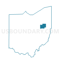
PERRY TWP 1 Voting District, Stark County, Ohio
About
Outline

Summary
| Unique Area Identifier | 651670 |
| Name | PERRY TWP 1 Voting District |
| County | Stark County |
| State | Ohio |
| Area (square miles) | 0.22 |
| Land Area (square miles) | 0.22 |
| Water Area (square miles) | 0.00 |
| % of Land Area | 100.00 |
| % of Water Area | 0.00 |
| Latitude of the Internal Point | 40.80234630 |
| Longtitude of the Internal Point | -81.47578030 |
Maps


Graphs
Select a template below for downloading or customizing gragh for PERRY TWP 1 Voting District, Stark County, Ohio


Neighbors
Neighoring Voting District (by Name) Neighboring Voting District on the Map
- PERRY TWP 16 Voting District, Stark County, OH
- PERRY TWP 19 Voting District, Stark County, OH
- PERRY TWP 2 Voting District, Stark County, OH
- PERRY TWP 21 Voting District, Stark County, OH
- PERRY TWP 22 Voting District, Stark County, OH
- PERRY TWP 24 Voting District, Stark County, OH
- PERRY TWP 29 Voting District, Stark County, OH