


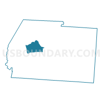
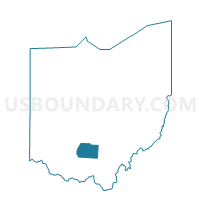
CONCORD ROXABELL Voting District, Ross County, Ohio
About
Outline

Summary
| Unique Area Identifier | 651413 |
| Name | CONCORD ROXABELL Voting District |
| County | Ross County |
| State | Ohio |
| Area (square miles) | 19.57 |
| Land Area (square miles) | 19.57 |
| Water Area (square miles) | 0.00 |
| % of Land Area | 100.00 |
| % of Water Area | 0.00 |
| Latitude of the Internal Point | 39.36276480 |
| Longtitude of the Internal Point | -83.18828470 |
Maps

Graphs
Select a template below for downloading or customizing gragh for CONCORD ROXABELL Voting District, Ross County, Ohio


Neighbors
Neighoring Voting District (by Name) Neighboring Voting District on the Map
- BUCKSKIN NORTH Voting District, Ross County, OH
- BUCKSKIN SOUTH Voting District, Ross County, OH
- CONCORD AUSTIN Voting District, Ross County, OH
- CONCORD FRANK CORP Voting District, Ross County, OH
- CONCORD FRANK PREC Voting District, Ross County, OH
- TWIN CENTRAL Voting District, Ross County, OH
- TWIN EAST Voting District, Ross County, OH
- UNION SOUTH Voting District, Ross County, OH
Top 10 Neighboring County Subdivision (by Population) Neighboring County Subdivision on the Map
- Union township, Ross County, OH (13,345)
- Concord township, Ross County, OH (4,460)
- Twin township, Ross County, OH (3,384)
- Buckskin township, Ross County, OH (2,039)
Top 10 Neighboring Place (by Population) Neighboring Place on the Map
Top 10 Neighboring Unified School District (by Population) Neighboring Unified School District on the Map
- Union-Scioto Local School District, OH (16,338)
- Greenfield Exempted Village School District, OH (12,428)
- Adena Local School District, OH (6,726)
- Paint Valley Local School District, OH (6,119)