


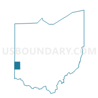
PRECINCT MONROE, Preble County, Ohio
About
Outline

Summary
| Unique Area Identifier | 651177 |
| Name | PRECINCT MONROE |
| County | Preble County |
| State | Ohio |
| Area (square miles) | 34.67 |
| Land Area (square miles) | 34.65 |
| Water Area (square miles) | 0.02 |
| % of Land Area | 99.94 |
| % of Water Area | 0.06 |
| Latitude of the Internal Point | 39.87357850 |
| Longtitude of the Internal Point | -84.64244320 |
Maps

Graphs
Select a template below for downloading or customizing gragh for PRECINCT MONROE, Preble County, Ohio


Neighbors
Neighoring Voting District (by Name) Neighboring Voting District on the Map
- PRECINCT BUTLER AND CASTINE VILLAGE, Darke County, OH
- PRECINCT ELDORADO, Preble County, OH
- PRECINCT HARRISON EAST & NEW MADISON, Darke County, OH
- PRECINCT HARRISON WEST, Preble County, OH
- PRECINCT JACKSON, Preble County, OH
- PRECINCT JEFFERSON NORTH, Preble County, OH
- PRECINCT JEFFERSON SOUTH, Preble County, OH
- PRECINCT TWIN TWP GORDON & ITHACA, Darke County, OH
- PRECINCT TWIN WEST, Preble County, OH
- PRECINCT WASHINGTON EAST, Preble County, OH
- PRECINCT WASHINGTON WEST, Preble County, OH
- PRECINCT WEST MANCHESTER, Preble County, OH
Top 10 Neighboring County Subdivision (by Population) Neighboring County Subdivision on the Map
- Harrison township, Preble County, OH (4,594)
- Twin township, Darke County, OH (4,060)
- Jefferson township, Preble County, OH (3,309)
- Twin township, Preble County, OH (2,790)
- Monroe township, Preble County, OH (2,258)
- Harrison township, Darke County, OH (2,255)
- Washington township, Preble County, OH (1,824)
- Butler township, Darke County, OH (1,535)
- Jackson township, Preble County, OH (1,190)
Top 10 Neighboring Place (by Population) Neighboring Place on the Map
Top 10 Neighboring Unified School District (by Population) Neighboring Unified School District on the Map
- National Trail Local School District, OH (7,004)
- Tri-County North Local School District, OH (5,949)
- Arcanum-Butler Local School District, OH (5,856)
- Tri-Village Local School District, OH (4,375)
Top 10 Neighboring State Legislative District Lower Chamber (by Population) Neighboring State Legislative District Lower Chamber on the Map
Top 10 Neighboring State Legislative District Upper Chamber (by Population) Neighboring State Legislative District Upper Chamber on the Map
Top 10 Neighboring 111th Congressional District (by Population) Neighboring 111th Congressional District on the Map
Top 10 Neighboring Census Tract (by Population) Neighboring Census Tract on the Map
- Census Tract 5601, Darke County, OH (7,191)
- Census Tract 5701.02, Darke County, OH (5,795)
- Census Tract 4201, Preble County, OH (4,594)
- Census Tract 4001, Preble County, OH (3,309)
- Census Tract 4601, Preble County, OH (2,926)
- Census Tract 4301, Preble County, OH (2,790)
- Census Tract 4101, Preble County, OH (2,258)
- Census Tract 4501, Preble County, OH (2,119)
Top 10 Neighboring 5-Digit ZIP Code Tabulation Area (by Population) Neighboring 5-Digit ZIP Code Tabulation Area on the Map
- 45320, OH (15,691)
- 45338, OH (5,298)
- 45347, OH (4,324)
- 45346, OH (2,293)
- 45382, OH (1,269)
- 45321, OH (931)