


PRECINCT SALT CREEK, Muskingum County, Ohio
About
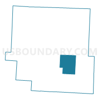
Outline

Summary
| Unique Area Identifier | 650774 |
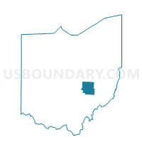
| Name | PRECINCT SALT CREEK |
| County | Muskingum County |
| State | Ohio |
| Area (square miles) | 27.91 |
| Land Area (square miles) | 27.90 |
| Water Area (square miles) | 0.01 |
| % of Land Area | 99.97 |
| % of Water Area | 0.03 |
| Latitude of the Internal Point | 39.89290500 |
| Longtitude of the Internal Point | -81.85044240 |
Maps

Graphs
Select a template below for downloading or customizing gragh for PRECINCT SALT CREEK, Muskingum County, Ohio


Neighbors
Neighoring Voting District (by Name) Neighboring Voting District on the Map
- PRECINCT BLUE ROCK, Muskingum County, OH
- PRECINCT DUNCAN FALLS, Muskingum County, OH
- PRECINCT MEIGS, Muskingum County, OH
- PRECINCT NORWICH, Muskingum County, OH
- PRECINCT PERRY SOUTH, Muskingum County, OH
- PRECINCT RICH HILL, Muskingum County, OH
- PRECINCT WAYNE C, Muskingum County, OH
Top 10 Neighboring County Subdivision (by Population) Neighboring County Subdivision on the Map
- Wayne township, Muskingum County, OH (4,731)
- Union township, Muskingum County, OH (4,395)
- Perry township, Muskingum County, OH (2,621)
- Salt Creek township, Muskingum County, OH (1,112)
- Blue Rock township, Muskingum County, OH (677)
- Rich Hill township, Muskingum County, OH (454)
- Meigs township, Muskingum County, OH (180)
Top 10 Neighboring Unified School District (by Population) Neighboring Unified School District on the Map
Top 10 Neighboring State Legislative District Lower Chamber (by Population) Neighboring State Legislative District Lower Chamber on the Map
Top 10 Neighboring State Legislative District Upper Chamber (by Population) Neighboring State Legislative District Upper Chamber on the Map
Top 10 Neighboring 111th Congressional District (by Population) Neighboring 111th Congressional District on the Map
Top 10 Neighboring Census Tract (by Population) Neighboring Census Tract on the Map
- Census Tract 9128, Muskingum County, OH (6,066)
- Census Tract 9127, Muskingum County, OH (5,533)
- Census Tract 9126, Muskingum County, OH (3,322)
Top 10 Neighboring 5-Digit ZIP Code Tabulation Area (by Population) Neighboring 5-Digit ZIP Code Tabulation Area on the Map
- 43701, OH (55,643)
- 43762, OH (5,413)
- 43727, OH (1,473)
- 43767, OH (1,443)
- 43720, OH (1,300)
- 43734, OH (1,171)