


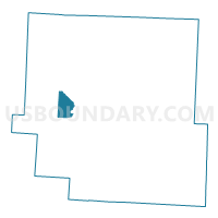
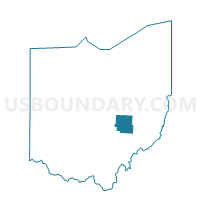
PRECINCT FALLS G, Muskingum County, Ohio
About
Outline

Summary
| Unique Area Identifier | 650745 |
| Name | PRECINCT FALLS G |
| County | Muskingum County |
| State | Ohio |
| Area (square miles) | 6.34 |
| Land Area (square miles) | 6.32 |
| Water Area (square miles) | 0.02 |
| % of Land Area | 99.75 |
| % of Water Area | 0.25 |
| Latitude of the Internal Point | 39.96729230 |
| Longtitude of the Internal Point | -82.08930550 |
Maps

Graphs
Select a template below for downloading or customizing gragh for PRECINCT FALLS G, Muskingum County, Ohio


Neighbors
Neighoring Voting District (by Name) Neighboring Voting District on the Map
- PRECINCT FALLS B, Muskingum County, OH
- PRECINCT FALLS C, Muskingum County, OH
- PRECINCT HOPEWELL B, Muskingum County, OH
- PRECINCT HOPEWELL C, Muskingum County, OH
- PRECINCT SPRINGFIELD C, Muskingum County, OH
Top 10 Neighboring County Subdivision (by Population) Neighboring County Subdivision on the Map
- Falls township, Muskingum County, OH (8,131)
- Springfield township, Muskingum County, OH (5,602)
- Hopewell township, Muskingum County, OH (3,093)