


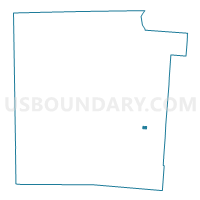
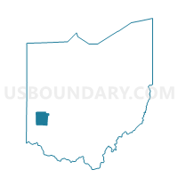
PRECINCT KETTERING 4-S, Montgomery County, Ohio
About
Outline

Summary
| Unique Area Identifier | 650604 |
| Name | PRECINCT KETTERING 4-S |
| County | Montgomery County |
| State | Ohio |
| Area (square miles) | 0.15 |
| Land Area (square miles) | 0.14 |
| Water Area (square miles) | 0.00 |
| % of Land Area | 98.38 |
| % of Water Area | 1.62 |
| Latitude of the Internal Point | 39.69920350 |
| Longtitude of the Internal Point | -84.15795160 |
Maps

Graphs
Select a template below for downloading or customizing gragh for PRECINCT KETTERING 4-S, Montgomery County, Ohio


Neighbors
Neighoring Voting District (by Name) Neighboring Voting District on the Map
- PRECINCT KETTERING 4-I, Montgomery County, OH
- PRECINCT KETTERING 4-J, Montgomery County, OH
- PRECINCT KETTERING 4-N, Montgomery County, OH
- PRECINCT KETTERING 4-O, Montgomery County, OH
- PRECINCT KETTERING 4-P, Montgomery County, OH