


RACINE PRECINCT, Meigs County, Ohio
About
Outline
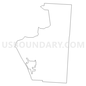
Summary
| Unique Area Identifier | 649979 |
| Name | RACINE PRECINCT |
| County | Meigs County |
| State | Ohio |
| Area (square miles) | 16.03 |
| Land Area (square miles) | 15.88 |
| Water Area (square miles) | 0.15 |
| % of Land Area | 99.04 |
| % of Water Area | 0.96 |
| Latitude of the Internal Point | 38.98336720 |
| Longtitude of the Internal Point | -81.87817450 |
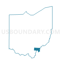
Maps


Graphs
Select a template below for downloading or customizing gragh for RACINE PRECINCT, Meigs County, Ohio


Neighbors
Neighoring Voting District (by Name) Neighboring Voting District on the Map
- Voting District 13, Mason County, WV
- Voting District 8, Mason County, WV
- EAST CHESTER Voting District, Meigs County, OH
- LEBANON Voting District, Meigs County, OH
- LETART Voting District, Meigs County, OH
- MINERSVILLE Voting District, Meigs County, OH
- RACINE VILLAGE Voting District, Meigs County, OH
- SYRACUSE VILLAGE Voting District, Meigs County, OH
Top 10 Neighboring County Subdivision (by Population) Neighboring County Subdivision on the Map
- Sutton township, Meigs County, OH (3,140)
- Graham district, Mason County, WV (2,756)
- Chester township, Meigs County, OH (2,496)
- Lebanon township, Meigs County, OH (967)
- Letart township, Meigs County, OH (675)
Top 10 Neighboring Place (by Population) Neighboring Place on the Map
Top 10 Neighboring Unified School District (by Population) Neighboring Unified School District on the Map
- Mason County School District, WV (27,324)
- Eastern Local School District, OH (5,180)
- Southern Local School District, OH (4,736)
Top 10 Neighboring State Legislative District Lower Chamber (by Population) Neighboring State Legislative District Lower Chamber on the Map
Top 10 Neighboring State Legislative District Upper Chamber (by Population) Neighboring State Legislative District Upper Chamber on the Map
Top 10 Neighboring 111th Congressional District (by Population) Neighboring 111th Congressional District on the Map
Top 10 Neighboring Census Tract (by Population) Neighboring Census Tract on the Map
- Census Tract 9641, Meigs County, OH (4,209)
- Census Tract 9548.02, Mason County, WV (4,133)
- Census Tract 9646, Meigs County, OH (3,332)
- Census Tract 9645, Meigs County, OH (3,092)