


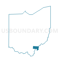
SOUTH OLIVE Voting District, Meigs County, Ohio
About
Outline

Summary
| Unique Area Identifier | 649978 |
| Name | SOUTH OLIVE Voting District |
| County | Meigs County |
| State | Ohio |
| Area (square miles) | 24.04 |
| Land Area (square miles) | 23.42 |
| Water Area (square miles) | 0.62 |
| % of Land Area | 97.41 |
| % of Water Area | 2.59 |
| Latitude of the Internal Point | 39.11165770 |
| Longtitude of the Internal Point | -81.80274450 |
Maps


Graphs
Select a template below for downloading or customizing gragh for SOUTH OLIVE Voting District, Meigs County, Ohio


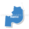

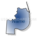

Neighbors
Neighoring Voting District (by Name) Neighboring Voting District on the Map
- Voting District 1, Jackson County, WV
- Voting District 82, Wood County, WV
- EAST CHESTER Voting District, Meigs County, OH
- LEBANON Voting District, Meigs County, OH
- NORTH OLIVE Voting District, Meigs County, OH
- Voting District TROY WEST, Athens County, OH
Top 10 Neighboring County Subdivision (by Population) Neighboring County Subdivision on the Map
- Northern district, Jackson County, WV (8,753)
- Troy township, Athens County, OH (2,617)
- Chester township, Meigs County, OH (2,496)
- Harris district, Wood County, WV (1,820)
- Olive township, Meigs County, OH (1,798)
- Lebanon township, Meigs County, OH (967)
Top 10 Neighboring Unified School District (by Population) Neighboring Unified School District on the Map
- Wood County School District, WV (86,956)
- Jackson County School District, WV (29,211)
- Federal Hocking Local School District, OH (8,100)
- Eastern Local School District, OH (5,180)
Top 10 Neighboring State Legislative District Lower Chamber (by Population) Neighboring State Legislative District Lower Chamber on the Map
- State House District 92, OH (123,037)
- State House District 12, WV (20,112)
- State House District 9, WV (19,202)
Top 10 Neighboring State Legislative District Upper Chamber (by Population) Neighboring State Legislative District Upper Chamber on the Map
- State Senate District 20, OH (357,708)
- State Senate District 4, WV (117,998)
- State Senate District 3, WV (109,227)
Top 10 Neighboring 111th Congressional District (by Population) Neighboring 111th Congressional District on the Map
- Congressional District 2, WV (648,186)
- Congressional District 6, OH (623,742)
- Congressional District 1, WV (615,991)
Top 10 Neighboring Census Tract (by Population) Neighboring Census Tract on the Map
- Census Tract 9632, Jackson County, WV (4,620)
- Census Tract 9641, Meigs County, OH (4,209)
- Census Tract 9736, Athens County, OH (3,972)
- Census Tract 108, Wood County, WV (3,153)
Top 10 Neighboring 5-Digit ZIP Code Tabulation Area (by Population) Neighboring 5-Digit ZIP Code Tabulation Area on the Map
- 26164, WV (8,262)
- 26181, WV (6,127)
- 45723, OH (3,740)
- 45772, OH (2,149)
- 45743, OH (1,449)
- 26133, WV (1,415)