


PRECINCT LONDON 1-D, Madison County, Ohio
About
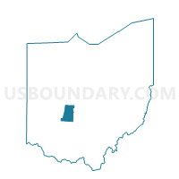
Outline

Summary
| Unique Area Identifier | 649441 |
| Name | PRECINCT LONDON 1-D |
| County | Madison County |
| State | Ohio |
| Area (square miles) | 1.53 |
| Land Area (square miles) | 1.53 |
| Water Area (square miles) | 0.00 |
| % of Land Area | 100.00 |
| % of Water Area | 0.00 |
| Latitude of the Internal Point | 39.91243200 |
| Longtitude of the Internal Point | -83.43937510 |
Maps


Graphs
Select a template below for downloading or customizing gragh for PRECINCT LONDON 1-D, Madison County, Ohio


Neighbors
Neighoring Voting District (by Name) Neighboring Voting District on the Map
- PRECINCT DEERCREEK, Madison County, OH
- PRECINCT LONDON 1-C, Madison County, OH
- PRECINCT LONDON 2-C, Madison County, OH
- PRECINCT LONDON 4-B, Madison County, OH
- PRECINCT SOMERFORD, Madison County, OH
- PRECINCT UNION WEST, Madison County, OH
Top 10 Neighboring County Subdivision (by Population) Neighboring County Subdivision on the Map
- London city, Madison County, OH (9,904)
- Union township, Madison County, OH (6,246)
- Somerford township, Madison County, OH (2,898)
- Deer Creek township, Madison County, OH (933)