


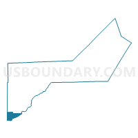
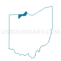
PROVIDENCE 2 Voting District, Lucas County, Ohio
About
Outline

Summary
| Unique Area Identifier | 649352 |
| Name | PROVIDENCE 2 Voting District |
| County | Lucas County |
| State | Ohio |
| Area (square miles) | 9.49 |
| Land Area (square miles) | 9.00 |
| Water Area (square miles) | 0.49 |
| % of Land Area | 94.83 |
| % of Water Area | 5.17 |
| Latitude of the Internal Point | 41.43876950 |
| Longtitude of the Internal Point | -83.84954690 |
Maps

Graphs
Select a template below for downloading or customizing gragh for PROVIDENCE 2 Voting District, Lucas County, Ohio


Neighbors
Neighoring Voting District (by Name) Neighboring Voting District on the Map
- Voting District DAMASCUS, Henry County, OH
- GRAND RAPIDS TWP GR Voting District, Wood County, OH
- GRAND RAPIDS TWP PARK Voting District, Wood County, OH
- PROVIDENCE 3 Voting District, Lucas County, OH
- PROVIDENCE 4 Voting District, Lucas County, OH
- Voting District WASHINGTON NORTH, Henry County, OH
- Voting District WASHINGTON SOUTH, Henry County, OH
- WASHINGTON TWP Voting District, Wood County, OH
- WATERVILLE 1 Voting District, Lucas County, OH
- WATERVILLE 8 Voting District, Lucas County, OH
Top 10 Neighboring County Subdivision (by Population) Neighboring County Subdivision on the Map
- Waterville township, Lucas County, OH (11,336)
- Providence township, Lucas County, OH (3,361)
- Washington township, Henry County, OH (1,912)
- Washington township, Wood County, OH (1,841)
- Damascus township, Henry County, OH (1,801)
- Grand Rapids township, Wood County, OH (1,607)
Top 10 Neighboring Place (by Population) Neighboring Place on the Map
Top 10 Neighboring Unified School District (by Population) Neighboring Unified School District on the Map
- Anthony Wayne Local School District, OH (27,810)
- Otsego Local School District, OH (9,825)
- Liberty Center Local School District, OH (5,652)
Top 10 Neighboring State Legislative District Lower Chamber (by Population) Neighboring State Legislative District Lower Chamber on the Map
- State House District 46, OH (127,690)
- State House District 6, OH (125,488)
- State House District 75, OH (112,019)
Top 10 Neighboring State Legislative District Upper Chamber (by Population) Neighboring State Legislative District Upper Chamber on the Map
Top 10 Neighboring 111th Congressional District (by Population) Neighboring 111th Congressional District on the Map
Top 10 Neighboring Census Tract (by Population) Neighboring Census Tract on the Map
- Census Tract 89.02, Lucas County, OH (6,125)
- Census Tract 1, Henry County, OH (4,721)
- Census Tract 213, Wood County, OH (3,448)
- Census Tract 96, Lucas County, OH (3,361)