


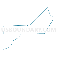
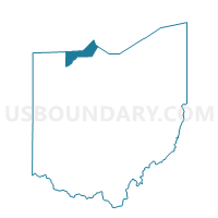
TOLEDO 1A Voting District, Lucas County, Ohio
About
Outline

Summary
| Unique Area Identifier | 649311 |
| Name | TOLEDO 1A Voting District |
| County | Lucas County |
| State | Ohio |
| Area (square miles) | 0.19 |
| Land Area (square miles) | 0.19 |
| Water Area (square miles) | 0.00 |
| % of Land Area | 100.00 |
| % of Water Area | 0.00 |
| Latitude of the Internal Point | 41.73019370 |
| Longtitude of the Internal Point | -83.46006780 |
Maps

Graphs
Select a template below for downloading or customizing gragh for TOLEDO 1A Voting District, Lucas County, Ohio


Neighbors
Neighoring Voting District (by Name) Neighboring Voting District on the Map
- Voting District 1152632000001, Monroe County, MI
- TOLEDO 1B Voting District, Lucas County, OH
- Water, Lucas County, OH
- Voting Districts not defined, Monroe County, MI
Top 10 Neighboring County Subdivision (by Population) Neighboring County Subdivision on the Map
- Toledo city, Lucas County, OH (287,208)
- Erie township, Monroe County, MI (4,517)
- Washington township, Lucas County, OH (3,278)
Top 10 Neighboring Place (by Population) Neighboring Place on the Map
Top 10 Neighboring Unified School District (by Population) Neighboring Unified School District on the Map
- Toledo City School District, OH (232,776)
- Mason Consolidated Schools, MI (7,859)
- School District Not Defined (Water), OH (4)