


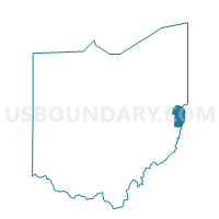
PRECINCT WINTERSVILLE C, Jefferson County, Ohio
About
Outline

Summary
| Unique Area Identifier | 648116 |
| Name | PRECINCT WINTERSVILLE C |
| County | Jefferson County |
| State | Ohio |
| Area (square miles) | 0.33 |
| Land Area (square miles) | 0.33 |
| Water Area (square miles) | 0.00 |
| % of Land Area | 100.00 |
| % of Water Area | 0.00 |
| Latitude of the Internal Point | 40.37524210 |
| Longtitude of the Internal Point | -80.71254300 |
Maps


Graphs
Select a template below for downloading or customizing gragh for PRECINCT WINTERSVILLE C, Jefferson County, Ohio


Neighbors
Neighoring Voting District (by Name) Neighboring Voting District on the Map
- PRECINCT BRENTWOOD, Jefferson County, OH
- PRECINCT WEST PARK, Jefferson County, OH
- PRECINCT WINTERSVILLE A, Jefferson County, OH
- PRECINCT WINTERSVILLE B, Jefferson County, OH
- PRECINCT WINTERSVILLE D, Jefferson County, OH
Top 10 Neighboring County Subdivision (by Population) Neighboring County Subdivision on the Map
- Island Creek township, Jefferson County, OH (10,546)
- Cross Creek township, Jefferson County, OH (8,348)