


PRECINCT PER TWP #9, Erie County, Ohio
About
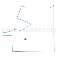
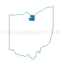
Outline

Summary
| Unique Area Identifier | 645529 |
| Name | PRECINCT PER TWP #9 |
| County | Erie County |
| State | Ohio |
| Area (square miles) | 0.76 |
| Land Area (square miles) | 0.75 |
| Water Area (square miles) | 0.01 |
| % of Land Area | 99.14 |
| % of Water Area | 0.86 |
| Latitude of the Internal Point | 41.40247920 |
| Longtitude of the Internal Point | -82.68791120 |
Maps

Graphs
Select a template below for downloading or customizing gragh for PRECINCT PER TWP #9, Erie County, Ohio


Neighbors
Neighoring Voting District (by Name) Neighboring Voting District on the Map
- PRECINCT PER TWP #10, Erie County, OH
- PRECINCT PER TWP #2, Erie County, OH
- PRECINCT PER TWP #7, Erie County, OH
- PRECINCT PER TWP #8, Erie County, OH