


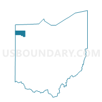
Mark Township, Defiance County, Ohio
About
Outline

Summary
| Unique Area Identifier | 645358 |
| Name | Mark Township |
| County | Defiance County |
| State | Ohio |
| Area (square miles) | 36.64 |
| Land Area (square miles) | 36.64 |
| Water Area (square miles) | 0.00 |
| % of Land Area | 100.00 |
| % of Water Area | 0.00 |
| Latitude of the Internal Point | 41.29630780 |
| Longtitude of the Internal Point | -84.63106820 |
Maps


Graphs
Select a template below for downloading or customizing gragh for Mark Township, Defiance County, Ohio


Neighbors
Neighoring Voting District (by Name) Neighboring Voting District on the Map
- Voting District CARRYALL TWP, Paulding County, OH
- Voting District CRANE TWP & CECIL, Paulding County, OH
- Delaware Township B, Defiance County, OH
- Voting District EMERALD TWP, Paulding County, OH
- Farmer Township, Defiance County, OH
- Hicksville Township, Defiance County, OH
- Milford Township, Defiance County, OH
- Washington Township, Defiance County, OH
Top 10 Neighboring County Subdivision (by Population) Neighboring County Subdivision on the Map
- Hicksville township, Defiance County, OH (4,979)
- Carryall township, Paulding County, OH (2,980)
- Delaware township, Defiance County, OH (2,134)
- Washington township, Defiance County, OH (1,617)
- Crane township, Paulding County, OH (1,420)
- Milford township, Defiance County, OH (1,081)
- Farmer township, Defiance County, OH (963)
- Mark township, Defiance County, OH (908)
- Emerald township, Paulding County, OH (789)
Top 10 Neighboring Unified School District (by Population) Neighboring Unified School District on the Map
- Paulding Exempted Village School District, OH (10,261)
- Central Local School District, OH (6,280)
- Hicksville Exempted Village School District, OH (5,350)
- Antwerp Local School District, OH (3,857)
Top 10 Neighboring State Legislative District Lower Chamber (by Population) Neighboring State Legislative District Lower Chamber on the Map
Top 10 Neighboring State Legislative District Upper Chamber (by Population) Neighboring State Legislative District Upper Chamber on the Map
Top 10 Neighboring 111th Congressional District (by Population) Neighboring 111th Congressional District on the Map
Top 10 Neighboring Census Tract (by Population) Neighboring Census Tract on the Map
- Census Tract 9582, Defiance County, OH (4,568)
- Census Tract 9602, Paulding County, OH (4,339)
- Census Tract 9584, Defiance County, OH (4,136)