


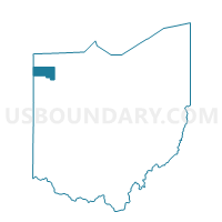
No Richland Township, Defiance County, Ohio
About
Outline

Summary
| Unique Area Identifier | 645344 |
| Name | No Richland Township |
| County | Defiance County |
| State | Ohio |
| Area (square miles) | 19.11 |
| Land Area (square miles) | 18.78 |
| Water Area (square miles) | 0.34 |
| % of Land Area | 98.24 |
| % of Water Area | 1.76 |
| Latitude of the Internal Point | 41.31645860 |
| Longtitude of the Internal Point | -84.27576360 |
Maps


Graphs
Select a template below for downloading or customizing gragh for No Richland Township, Defiance County, Ohio


Neighbors
Neighoring Voting District (by Name) Neighboring Voting District on the Map
- Adams Township, Defiance County, OH
- Defiance City 3-C, Defiance County, OH
- Defiance City 3-D, Defiance County, OH
- Defiance City 4-D, Defiance County, OH
- Voting District FLATROCK NORTH, Henry County, OH
- Voting District FLATROCK SOUTH, Henry County, OH
- Voting District NAPOLEON WEST, Henry County, OH
- Noble Township A, Defiance County, OH
- So. Richland Twp. A, Defiance County, OH
- Tiffin Township A, Defiance County, OH
Top 10 Neighboring County Subdivision (by Population) Neighboring County Subdivision on the Map
- Defiance township, Defiance County, OH (13,178)
- Napoleon township, Henry County, OH (9,796)
- Noble township, Defiance County, OH (6,326)
- Richland township, Defiance County, OH (2,920)
- Tiffin township, Defiance County, OH (1,612)
- Flatrock township, Henry County, OH (1,247)
- Adams township, Defiance County, OH (947)
Top 10 Neighboring Place (by Population) Neighboring Place on the Map
Top 10 Neighboring Unified School District (by Population) Neighboring Unified School District on the Map
- Defiance City School District, OH (16,675)
- Napoleon Area City School District, OH (14,482)
- Northeastern Local School District, OH (6,760)
- Ayersville Local School District, OH (3,974)
Top 10 Neighboring State Legislative District Lower Chamber (by Population) Neighboring State Legislative District Lower Chamber on the Map
Top 10 Neighboring State Legislative District Upper Chamber (by Population) Neighboring State Legislative District Upper Chamber on the Map
Top 10 Neighboring 111th Congressional District (by Population) Neighboring 111th Congressional District on the Map
Top 10 Neighboring Census Tract (by Population) Neighboring Census Tract on the Map
- Census Tract 9581, Defiance County, OH (4,572)
- Census Tract 9585, Defiance County, OH (4,369)
- Census Tract 2, Henry County, OH (3,830)
- Census Tract 9588, Defiance County, OH (3,665)