


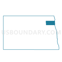
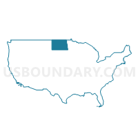
Walsh 16-07 Voting District, Walsh County, North Dakota
About
Outline

Summary
| Unique Area Identifier | 642364 |
| Name | Walsh 16-07 Voting District |
| County | Walsh County |
| State | North Dakota |
| Area (square miles) | 106.55 |
| Land Area (square miles) | 106.47 |
| Water Area (square miles) | 0.08 |
| % of Land Area | 99.93 |
| % of Water Area | 0.07 |
| Latitude of the Internal Point | 48.37645290 |
| Longtitude of the Internal Point | -97.67715310 |
Maps

Graphs
Select a template below for downloading or customizing gragh for Walsh 16-07 Voting District, Walsh County, North Dakota


Neighbors
Neighoring Voting District (by Name) Neighboring Voting District on the Map
- Walsh 16-02 Voting District, Walsh County, ND
- Walsh 16-03 Voting District, Walsh County, ND
- Walsh 16-04 Voting District, Walsh County, ND
- Walsh 16-06 Voting District, Walsh County, ND
- Walsh 16-08 Voting District, Walsh County, ND
- Walsh 16-15 Voting District, Walsh County, ND
- Walsh 16-16 Voting District, Walsh County, ND
- Walsh 16-17 Voting District, Walsh County, ND
Top 10 Neighboring County Subdivision (by Population) Neighboring County Subdivision on the Map
- Park River city, Walsh County, ND (1,403)
- Grafton township, Walsh County, ND (288)
- Fertile township, Walsh County, ND (250)
- Kensington township, Walsh County, ND (244)
- Glenwood township, Walsh County, ND (201)
- Farmington township, Walsh County, ND (176)
- Prairie Centre township, Walsh County, ND (107)
- Lampton township, Walsh County, ND (106)
- Pisek city, Walsh County, ND (106)
- Golden township, Walsh County, ND (101)
Top 10 Neighboring Place (by Population) Neighboring Place on the Map
Top 10 Neighboring Unified School District (by Population) Neighboring Unified School District on the Map
- Grafton Public School District 3, ND (5,299)
- Park River Public School District 78, ND (2,366)
- Fordville-Lankin Public School District 5, ND (663)