


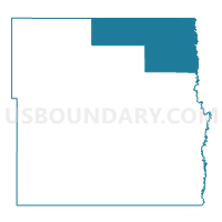
Cass Precinct 20-02, Cass County, North Dakota
About
Outline

Summary
| Unique Area Identifier | 642002 |
| Name | Cass Precinct 20-02 |
| County | Cass County |
| State | North Dakota |
| Area (square miles) | 209.17 |
| Land Area (square miles) | 209.10 |
| Water Area (square miles) | 0.08 |
| % of Land Area | 99.96 |
| % of Water Area | 0.04 |
| Latitude of the Internal Point | 47.15906530 |
| Longtitude of the Internal Point | -97.03771240 |
Maps
Graphs
Select a template below for downloading or customizing gragh for Cass Precinct 20-02, Cass County, North Dakota


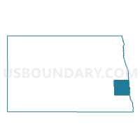
Neighbors
Neighoring Voting District (by Name) Neighboring Voting District on the Map
- Cass Precinct 20-01, Cass County, ND
- Cass Precinct 22-02, Cass County, ND
- Cass Precinct 22-04, Cass County, ND
- Georgetown Twp. Voting District, Clay County, MN
- Hendrum Twp. Voting District, Norman County, MN
- Kragnes Twp. Voting District, Clay County, MN
- Lee Twp. Voting District, Norman County, MN
- Traill 20-04 Voting District, Traill County, ND
- Traill 20-05 Voting District, Traill County, ND
- Traill 20-11 Voting District, Traill County, ND
Top 10 Neighboring County Subdivision (by Population) Neighboring County Subdivision on the Map
- Argusville city, Cass County, ND (475)
- Harwood township, Cass County, ND (352)
- Kragnes township, Clay County, MN (293)
- Hunter city, Cass County, ND (261)
- Grandin city, Cass County, ND (173)
- Georgetown township, Clay County, MN (156)
- Lee township, Norman County, MN (128)
- Berlin township, Cass County, ND (124)
- Erie township, Cass County, ND (109)
- Gardner township, Cass County, ND (107)
Top 10 Neighboring Place (by Population) Neighboring Place on the Map
Top 10 Neighboring Unified School District (by Population) Neighboring Unified School District on the Map
- Moorhead Public School District, MN (42,969)
- May-Port CG Public School District 14, ND (3,762)
- Hillsboro Public School District 9, ND (2,394)
- Northern Cass Public School District 97, ND (2,291)
- Norman County West School District, MN (1,472)
Top 10 Neighboring State Legislative District Lower Chamber (by Population) Neighboring State Legislative District Lower Chamber on the Map
- State House District 9A, MN (42,418)
- State House District 2A, MN (37,063)
- State House District 22, ND (20,531)
- State House District 20, ND (12,348)
Top 10 Neighboring State Legislative District Upper Chamber (by Population) Neighboring State Legislative District Upper Chamber on the Map
- State Senate District 9, MN (81,765)
- State Senate District 2, MN (76,807)
- State Senate District 22, ND (20,531)
- State Senate District 20, ND (12,348)
Top 10 Neighboring 111th Congressional District (by Population) Neighboring 111th Congressional District on the Map
Top 10 Neighboring Census Tract (by Population) Neighboring Census Tract on the Map
- Census Tract 404, Cass County, ND (3,576)
- Census Tract 403, Cass County, ND (3,213)
- Census Tract 402, Cass County, ND (2,291)
- Census Tract 9602, Norman County, MN (1,901)
- Census Tract 301.07, Clay County, MN (1,729)
- Census Tract 9703, Traill County, ND (1,492)
Top 10 Neighboring 5-Digit ZIP Code Tabulation Area (by Population) Neighboring 5-Digit ZIP Code Tabulation Area on the Map
- 56560, MN (40,766)
- 58005, ND (854)
- 58006, ND (427)
- 58048, ND (418)
- 56550, MN (414)
- 56546, MN (346)
- 58038, ND (332)
- 58036, ND (274)
- 56574, MN (266)
- 58035, ND (262)