


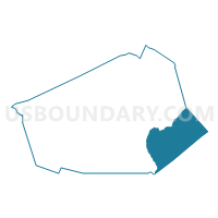
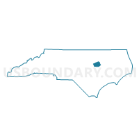
Voting District PRSA, Wilson County, North Carolina
About
Outline

Summary
| Unique Area Identifier | 641872 |
| Name | Voting District PRSA |
| County | Wilson County |
| State | North Carolina |
| Area (square miles) | 42.01 |
| Land Area (square miles) | 41.92 |
| Water Area (square miles) | 0.08 |
| % of Land Area | 99.80 |
| % of Water Area | 0.20 |
| Latitude of the Internal Point | 35.66247140 |
| Longtitude of the Internal Point | -77.74668630 |
Maps

Graphs
Select a template below for downloading or customizing gragh for Voting District PRSA, Wilson County, North Carolina


Neighbors
Neighoring Voting District (by Name) Neighboring Voting District on the Map
- Voting District 0901, Edgecombe County, NC
- Voting District 0901, Pitt County, NC
- Voting District PRGA, Wilson County, NC
- Voting District PRST, Wilson County, NC
- Voting District WALS, Greene County, NC
Top 10 Neighboring County Subdivision (by Population) Neighboring County Subdivision on the Map
- Gardners township, Wilson County, NC (3,870)
- Speights Bridge township, Greene County, NC (2,085)
- Stantonsburg township, Wilson County, NC (1,968)
- Township 9, Otter Creek, Edgecombe County, NC (1,807)
- Saratoga township, Wilson County, NC (1,665)
- Fountain township, Pitt County, NC (1,356)
Top 10 Neighboring Place (by Population) Neighboring Place on the Map
Top 10 Neighboring Unified School District (by Population) Neighboring Unified School District on the Map
- Pitt County Schools, NC (168,148)
- Wilson County Schools, NC (81,234)
- Edgecombe County Schools, NC (45,606)
- Greene County Schools, NC (21,362)
Top 10 Neighboring State Legislative District Lower Chamber (by Population) Neighboring State Legislative District Lower Chamber on the Map
- State House District 10, NC (77,125)
- State House District 23, NC (75,657)
- State House District 8, NC (69,997)
Top 10 Neighboring State Legislative District Upper Chamber (by Population) Neighboring State Legislative District Upper Chamber on the Map
- State Senate District 5, NC (183,899)
- State Senate District 11, NC (177,074)
- State Senate District 3, NC (167,669)
Top 10 Neighboring 111th Congressional District (by Population) Neighboring 111th Congressional District on the Map
Top 10 Neighboring Census Tract (by Population) Neighboring Census Tract on the Map
- Census Tract 12, Wilson County, NC (4,021)
- Census Tract 9501.01, Greene County, NC (4,018)
- Census Tract 8.02, Wilson County, NC (3,672)
- Census Tract 215, Edgecombe County, NC (3,313)
- Census Tract 216, Edgecombe County, NC (2,897)
- Census Tract 19, Pitt County, NC (2,889)
- Census Tract 10, Wilson County, NC (1,753)
- Census Tract 11, Wilson County, NC (1,665)
Top 10 Neighboring 5-Digit ZIP Code Tabulation Area (by Population) Neighboring 5-Digit ZIP Code Tabulation Area on the Map
- 27893, NC (39,723)
- 27822, NC (8,143)
- 27883, NC (3,565)
- 27852, NC (2,977)
- 27888, NC (2,560)
- 27829, NC (1,930)
- 27873, NC (397)