


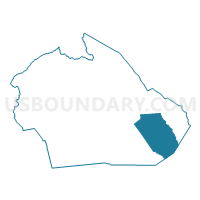
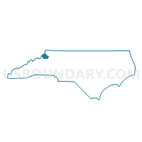
Voting District 09, Watauga County, North Carolina
About
Outline

Summary
| Unique Area Identifier | 641786 |
| Name | Voting District 09 |
| County | Watauga County |
| State | North Carolina |
| Area (square miles) | 23.37 |
| Land Area (square miles) | 23.36 |
| Water Area (square miles) | 0.00 |
| % of Land Area | 100.00 |
| % of Water Area | 0.00 |
| Latitude of the Internal Point | 36.18486850 |
| Longtitude of the Internal Point | -81.54201040 |
Maps

Graphs
Select a template below for downloading or customizing gragh for Voting District 09, Watauga County, North Carolina


Neighbors
Neighoring Voting District (by Name) Neighboring Voting District on the Map
- Voting District 04, Watauga County, NC
- Voting District 109, Wilkes County, NC
- Voting District 113, Wilkes County, NC
- Voting District 15, Watauga County, NC
- Voting District 18, Watauga County, NC
Top 10 Neighboring County Subdivision (by Population) Neighboring County Subdivision on the Map
- New River township, Watauga County, NC (11,838)
- Blue Ridge township, Watauga County, NC (4,211)
- Stony Fork township, Watauga County, NC (2,585)
- Elk township, Wilkes County, NC (1,002)
- Elk township, Watauga County, NC (638)
Top 10 Neighboring Unified School District (by Population) Neighboring Unified School District on the Map
Top 10 Neighboring State Legislative District Lower Chamber (by Population) Neighboring State Legislative District Lower Chamber on the Map
Top 10 Neighboring State Legislative District Upper Chamber (by Population) Neighboring State Legislative District Upper Chamber on the Map
Top 10 Neighboring 111th Congressional District (by Population) Neighboring 111th Congressional District on the Map
Top 10 Neighboring Census Tract (by Population) Neighboring Census Tract on the Map
- Census Tract 9609, Wilkes County, NC (5,144)
- Census Tract 9207.02, Watauga County, NC (2,928)
- Census Tract 9207.01, Watauga County, NC (2,158)