


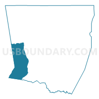
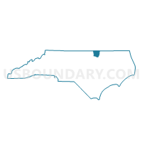
Voting District 6, Warren County, North Carolina
About
Outline

Summary
| Unique Area Identifier | 641772 |
| Name | Voting District 6 |
| County | Warren County |
| State | North Carolina |
| Area (square miles) | 33.26 |
| Land Area (square miles) | 33.11 |
| Water Area (square miles) | 0.15 |
| % of Land Area | 99.54 |
| % of Water Area | 0.46 |
| Latitude of the Internal Point | 36.32677410 |
| Longtitude of the Internal Point | -78.25677340 |
Maps

Graphs
Select a template below for downloading or customizing gragh for Voting District 6, Warren County, North Carolina


Neighbors
Neighoring Voting District (by Name) Neighboring Voting District on the Map
- Voting District 10, Warren County, NC
- Voting District 11, Franklin County, NC
- Voting District 12, Franklin County, NC
- Voting District 5, Warren County, NC
- Voting District 7, Warren County, NC
- Voting District MIDD, Vance County, NC
- Voting District SCRK, Vance County, NC
Top 10 Neighboring County Subdivision (by Population) Neighboring County Subdivision on the Map
- Sandy Creek township, Vance County, NC (6,711)
- Warrenton township, Warren County, NC (4,776)
- Middleburg township, Vance County, NC (3,712)
- Sandy Creek township, Franklin County, NC (2,718)
- Nutbush township, Warren County, NC (2,538)
- Hayesville township, Franklin County, NC (2,098)
- Sandy Creek township, Warren County, NC (1,866)
- Shocco township, Warren County, NC (1,358)
Top 10 Neighboring Unified School District (by Population) Neighboring Unified School District on the Map
- Franklin County Schools, NC (60,619)
- Vance County Schools, NC (45,422)
- Warren County Schools, NC (20,972)
Top 10 Neighboring State Legislative District Lower Chamber (by Population) Neighboring State Legislative District Lower Chamber on the Map
- State House District 32, NC (79,540)
- State House District 49, NC (77,779)
- State House District 27, NC (68,869)
Top 10 Neighboring State Legislative District Upper Chamber (by Population) Neighboring State Legislative District Upper Chamber on the Map
Top 10 Neighboring 111th Congressional District (by Population) Neighboring 111th Congressional District on the Map
Top 10 Neighboring Census Tract (by Population) Neighboring Census Tract on the Map
- Census Tract 9609, Vance County, NC (8,484)
- Census Tract 9502, Warren County, NC (6,676)
- Census Tract 601, Franklin County, NC (4,663)
- Census Tract 9503, Warren County, NC (4,414)
- Census Tract 9601, Vance County, NC (4,227)
- Census Tract 9504, Warren County, NC (3,723)