


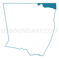
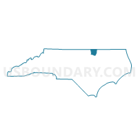
Voting District 12, Warren County, North Carolina
About
Outline

Summary
| Unique Area Identifier | 641762 |
| Name | Voting District 12 |
| County | Warren County |
| State | North Carolina |
| Area (square miles) | 13.35 |
| Land Area (square miles) | 9.27 |
| Water Area (square miles) | 4.08 |
| % of Land Area | 69.42 |
| % of Water Area | 30.58 |
| Latitude of the Internal Point | 36.53283080 |
| Longtitude of the Internal Point | -77.95112080 |
Maps

Graphs
Select a template below for downloading or customizing gragh for Voting District 12, Warren County, North Carolina


Neighbors
Neighoring Voting District (by Name) Neighboring Voting District on the Map
- Voting District 1, Warren County, NC
- Voting District 2, Warren County, NC
- Bracey Voting District, Mecklenburg County, VA
- Voting District LAKE G, Northampton County, NC
- Tillman Voting District, Brunswick County, VA
- Wright's Store Voting District, Mecklenburg County, VA
Top 10 Neighboring County Subdivision (by Population) Neighboring County Subdivision on the Map
- Gaston township, Northampton County, NC (5,973)
- District 3, Mecklenburg County, VA (4,134)
- District 1, Mecklenburg County, VA (3,444)
- Meherrin district, Brunswick County, VA (3,265)
- River township, Warren County, NC (1,352)
- Roanoke township, Warren County, NC (1,214)
- Sixpound township, Warren County, NC (1,061)
Top 10 Neighboring Place (by Population) Neighboring Place on the Map
Top 10 Neighboring Unified School District (by Population) Neighboring Unified School District on the Map
- Mecklenburg County Public Schools, VA (32,727)
- Northampton County Schools, NC (22,099)
- Warren County Schools, NC (20,972)
- Brunswick County Public Schools, VA (17,434)
Top 10 Neighboring State Legislative District Lower Chamber (by Population) Neighboring State Legislative District Lower Chamber on the Map
Top 10 Neighboring State Legislative District Upper Chamber (by Population) Neighboring State Legislative District Upper Chamber on the Map
- State Senate District 15, VA (191,067)
- State Senate District 7, NC (186,929)
- State Senate District 4, NC (163,184)
Top 10 Neighboring 111th Congressional District (by Population) Neighboring 111th Congressional District on the Map
Top 10 Neighboring Census Tract (by Population) Neighboring Census Tract on the Map
- Census Tract 9303, Brunswick County, VA (5,357)
- Census Tract 9301.02, Mecklenburg County, VA (2,933)
- Census Tract 9307, Mecklenburg County, VA (2,478)
- Census Tract 9501.01, Warren County, NC (2,210)
- Census Tract 9204.02, Northampton County, NC (1,500)
- Census Tract 9501.02, Warren County, NC (1,352)
Top 10 Neighboring 5-Digit ZIP Code Tabulation Area (by Population) Neighboring 5-Digit ZIP Code Tabulation Area on the Map
- 27850, NC (7,247)
- 23917, VA (3,684)
- 23919, VA (2,666)
- 27551, NC (1,962)
- 27842, NC (1,493)
- 23857, VA (525)
- 23893, VA (454)
- 23845, VA (356)