


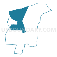
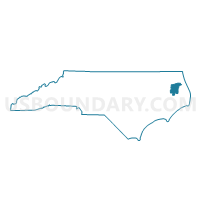
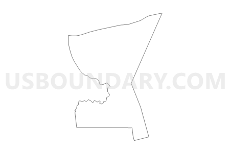
Voting District 02, Tyrrell County, North Carolina
About
Outline

Summary
| Unique Area Identifier | 641503 |
| Name | Voting District 02 |
| County | Tyrrell County |
| State | North Carolina |
| Area (square miles) | 121.85 |
| Land Area (square miles) | 69.35 |
| Water Area (square miles) | 52.49 |
| % of Land Area | 56.92 |
| % of Water Area | 43.08 |
| Latitude of the Internal Point | 35.94940200 |
| Longtitude of the Internal Point | -76.25903060 |
Maps

Graphs
Select a template below for downloading or customizing gragh for Voting District 02, Tyrrell County, North Carolina


Neighbors
Neighoring Voting District (by Name) Neighboring Voting District on the Map
- Voting District 01, Tyrrell County, NC
- Voting District 03, Tyrrell County, NC
- Voting District 15, Tyrrell County, NC
- Voting District 16, Tyrrell County, NC
- Voting District BETHEL, Perquimans County, NC
- Voting District NEW HO, Perquimans County, NC
- Voting District SAL, Pasquotank County, NC
- Voting District SK, Washington County, NC
Top 10 Neighboring County Subdivision (by Population) Neighboring County Subdivision on the Map
- Bethel township, Perquimans County, NC (3,848)
- New Hope township, Perquimans County, NC (3,005)
- Columbia township, Tyrrell County, NC (2,929)
- Salem township, Pasquotank County, NC (1,681)
- Skinnersville township, Washington County, NC (1,286)
- Scuppernong township, Tyrrell County, NC (673)
- Gum Neck township, Tyrrell County, NC (425)
- Alligator township, Tyrrell County, NC (330)
- South Fork township, Tyrrell County, NC (50)
Top 10 Neighboring Place (by Population) Neighboring Place on the Map
Top 10 Neighboring Unified School District (by Population) Neighboring Unified School District on the Map
- Pasquotank County Schools, NC (40,661)
- Perquimans County Schools, NC (13,453)
- Washington County Schools, NC (13,228)
- Tyrrell County Schools, NC (4,407)
Top 10 Neighboring State Legislative District Lower Chamber (by Population) Neighboring State Legislative District Lower Chamber on the Map
- State House District 1, NC (78,595)
- State House District 5, NC (71,601)
- State House District 2, NC (67,751)
Top 10 Neighboring State Legislative District Upper Chamber (by Population) Neighboring State Legislative District Upper Chamber on the Map
Top 10 Neighboring 111th Congressional District (by Population) Neighboring 111th Congressional District on the Map
Top 10 Neighboring Census Tract (by Population) Neighboring Census Tract on the Map
- Census Tract 9201, Perquimans County, NC (6,853)
- Census Tract 9501, Washington County, NC (5,069)
- Census Tract 9601, Tyrrell County, NC (4,407)
- Census Tract 9202.02, Perquimans County, NC (3,772)
- Census Tract 9607.02, Pasquotank County, NC (3,117)