


Voting District SW, Transylvania County, North Carolina
About
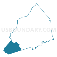
Outline

Summary
| Unique Area Identifier | 641482 |
| Name | Voting District SW |
| County | Transylvania County |
| State | North Carolina |
| Area (square miles) | 40.72 |
| Land Area (square miles) | 40.57 |
| Water Area (square miles) | 0.16 |
| % of Land Area | 99.61 |
| % of Water Area | 0.39 |
| Latitude of the Internal Point | 35.08304780 |
| Longtitude of the Internal Point | -82.97740490 |
Maps


Graphs
Select a template below for downloading or customizing gragh for Voting District SW, Transylvania County, North Carolina


Neighbors
Neighoring Voting District (by Name) Neighboring Voting District on the Map
- Voting District CAN, Jackson County, NC
- Voting District CAS, Jackson County, NC
- Holly Springs Voting District, Pickens County, SC
- Voting District LT, Transylvania County, NC
- Voting District QB, Transylvania County, NC
- Voting District RE, Transylvania County, NC
- Salem Voting District, Oconee County, SC
Top 10 Neighboring County Subdivision (by Population) Neighboring County Subdivision on the Map
- Salem CCD, Oconee County, SC (5,764)
- North Pickens CCD, Pickens County, SC (3,003)
- Eastatoe township, Transylvania County, NC (2,989)
- Hogback township, Transylvania County, NC (2,215)
- Cashiers township, Jackson County, NC (1,974)
- Canada township, Jackson County, NC (640)
Top 10 Neighboring Unified School District (by Population) Neighboring Unified School District on the Map
- Pickens County School District, SC (119,224)
- Oconee County School District, SC (74,273)
- Jackson County Schools, NC (36,627)
- Transylvania County Schools, NC (33,090)
Top 10 Neighboring State Legislative District Lower Chamber (by Population) Neighboring State Legislative District Lower Chamber on the Map
- State House District 113, NC (75,113)
- State House District 119, NC (73,640)
- State House District 1, SC (34,202)
- State House District 4, SC (33,418)
Top 10 Neighboring State Legislative District Upper Chamber (by Population) Neighboring State Legislative District Upper Chamber on the Map
- State Senate District 50, NC (175,858)
- State Senate District 2, SC (97,675)
- State Senate District 1, SC (95,822)
Top 10 Neighboring 111th Congressional District (by Population) Neighboring 111th Congressional District on the Map
Top 10 Neighboring Census Tract (by Population) Neighboring Census Tract on the Map
- Census Tract 302, Oconee County, SC (5,764)
- Census Tract 9605, Transylvania County, NC (5,710)
- Census Tract 101, Pickens County, SC (3,003)
- Census Tract 9507, Jackson County, NC (2,835)
- Census Tract 9606, Transylvania County, NC (2,506)
- Census Tract 9509, Jackson County, NC (2,270)
Top 10 Neighboring 5-Digit ZIP Code Tabulation Area (by Population) Neighboring 5-Digit ZIP Code Tabulation Area on the Map
- 28712, NC (19,347)
- 29676, SC (5,201)
- 28747, NC (2,198)
- 28717, NC (1,729)
- 29685, SC (1,230)
- 28774, NC (1,013)