


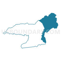
Voting District WHCH, Swain County, North Carolina
About
Outline

Summary
| Unique Area Identifier | 641477 |
| Name | Voting District WHCH |
| County | Swain County |
| State | North Carolina |
| Area (square miles) | 158.58 |
| Land Area (square miles) | 158.47 |
| Water Area (square miles) | 0.11 |
| % of Land Area | 99.93 |
| % of Water Area | 0.07 |
| Latitude of the Internal Point | 35.56252840 |
| Longtitude of the Internal Point | -83.29289840 |
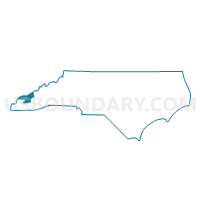
Maps

Graphs
Select a template below for downloading or customizing gragh for Voting District WHCH, Swain County, North Carolina


Neighbors
Neighoring Voting District (by Name) Neighboring Voting District on the Map
- 11-1 Gatlinburg Amer. Legion Voting District, Sevier County, TN
- Voting District ALARKA, Swain County, NC
- Voting District BC, Haywood County, NC
- Voting District BC1, Swain County, NC
- Voting District BC2, Swain County, NC
- Voting District BCK, Jackson County, NC
- Voting District IH, Haywood County, NC
- Voting District QUA, Jackson County, NC
Top 10 Neighboring County Subdivision (by Population) Neighboring County Subdivision on the Map
- Charleston township, Swain County, NC (11,982)
- District 11, Sevier County, TN (6,524)
- Qualla township, Jackson County, NC (6,161)
- Ivy Hill township, Haywood County, NC (4,866)
- Barkers Creek township, Jackson County, NC (1,839)
- Cataloochee township, Haywood County, NC (37)
Top 10 Neighboring Place (by Population) Neighboring Place on the Map
Top 10 Neighboring Unified School District (by Population) Neighboring Unified School District on the Map
- Sevier County School District, TN (89,889)
- Haywood County Schools, NC (59,036)
- Jackson County Schools, NC (36,627)
- Swain County Schools, NC (9,522)
- Eastern Cherokee Reservation, NC (8,103)
Top 10 Neighboring State Legislative District Lower Chamber (by Population) Neighboring State Legislative District Lower Chamber on the Map
- State House District 119, NC (73,640)
- State House District 118, NC (69,261)
- State House District 8, TN (66,531)
Top 10 Neighboring State Legislative District Upper Chamber (by Population) Neighboring State Legislative District Upper Chamber on the Map
- State Senate District 8, TN (212,899)
- State Senate District 50, NC (175,858)
- State Senate District 47, NC (168,288)
Top 10 Neighboring 111th Congressional District (by Population) Neighboring 111th Congressional District on the Map
Top 10 Neighboring Census Tract (by Population) Neighboring Census Tract on the Map
- Census Tract 9402, Jackson County, NC (5,910)
- Census Tract 9505, Jackson County, NC (5,488)
- Census Tract 9401, Swain County, NC (4,831)
- Census Tract 9207, Haywood County, NC (3,194)
- Census Tract 9602, Swain County, NC (3,043)
- Census Tract 9603.02, Swain County, NC (2,811)
- Census Tract 9801, Haywood County, NC (10)
- Census Tract 9801, Sevier County, TN (1)
- Census Tract 9802, Swain County, NC (0)
Top 10 Neighboring 5-Digit ZIP Code Tabulation Area (by Population) Neighboring 5-Digit ZIP Code Tabulation Area on the Map
- 28713, NC (8,686)
- 28719, NC (8,048)
- 28785, NC (7,338)
- 37738, TN (5,288)
- 28789, NC (5,097)
- 28751, NC (2,916)