


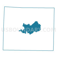
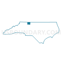
Voting District 01, Stokes County, North Carolina
About
Outline

Summary
| Unique Area Identifier | 641433 |
| Name | Voting District 01 |
| County | Stokes County |
| State | North Carolina |
| Area (square miles) | 31.34 |
| Land Area (square miles) | 31.09 |
| Water Area (square miles) | 0.25 |
| % of Land Area | 99.19 |
| % of Water Area | 0.81 |
| Latitude of the Internal Point | 36.40776060 |
| Longtitude of the Internal Point | -80.21652910 |
Maps

Graphs
Select a template below for downloading or customizing gragh for Voting District 01, Stokes County, North Carolina


Neighbors
Neighoring Voting District (by Name) Neighboring Voting District on the Map
- Voting District 02, Stokes County, NC
- Voting District 03, Stokes County, NC
- Voting District 08, Stokes County, NC
- Voting District 12, Stokes County, NC
- Voting District 14, Stokes County, NC
- Voting District 20, Stokes County, NC
Top 10 Neighboring County Subdivision (by Population) Neighboring County Subdivision on the Map
- Yadkin township, Stokes County, NC (21,834)
- Meadows township, Stokes County, NC (5,336)
- Beaver Island township, Stokes County, NC (3,707)
- Quaker Gap township, Stokes County, NC (2,818)
- Snow Creek township, Stokes County, NC (2,738)
- Peters Creek township, Stokes County, NC (2,026)
- Danbury township, Stokes County, NC (1,238)
Top 10 Neighboring Place (by Population) Neighboring Place on the Map
Top 10 Neighboring Unified School District (by Population) Neighboring Unified School District on the Map
Top 10 Neighboring State Legislative District Lower Chamber (by Population) Neighboring State Legislative District Lower Chamber on the Map
Top 10 Neighboring State Legislative District Upper Chamber (by Population) Neighboring State Legislative District Upper Chamber on the Map
Top 10 Neighboring 111th Congressional District (by Population) Neighboring 111th Congressional District on the Map
Top 10 Neighboring Census Tract (by Population) Neighboring Census Tract on the Map
- Census Tract 701, Stokes County, NC (6,720)
- Census Tract 706, Stokes County, NC (5,143)
- Census Tract 703, Stokes County, NC (4,732)
- Census Tract 702, Stokes County, NC (3,660)
Top 10 Neighboring 5-Digit ZIP Code Tabulation Area (by Population) Neighboring 5-Digit ZIP Code Tabulation Area on the Map
- 27021, NC (18,106)
- 27025, NC (11,138)
- 27052, NC (10,624)
- 27053, NC (3,007)
- 27046, NC (2,024)
- 27016, NC (1,936)